Alabama 811 | Know What's Below.

Archive for February 10th, 2010

Evening Update

Evening Update

| February 10, 2010 @ 8:56 pm | 73 Replies

A quick note from the forecast office this evening… the last three sets of the RPM, and the available 00Z global data suggest the ongoing forecast is in pretty good shape. Highlights…. *Very little snow north of I-20… *The I-20 corridor should see just a dusting, to around one inch in spots. Including Tuscaloosa, Birmingham, […]

Read More

Bad Day In The Weather Office (In Boston)

Bad Day In The Weather Office (In Boston)

| February 10, 2010 @ 8:35 pm | 1 Reply

Thanks to Jenny Henderson for passing this along… she writes: “Hello from Massachusetts! My husband and I moved to Massachusetts this fall. At one point we were predicted to have around 8 inches of snow today. That has been lowered to up to an inch. I thought you might appreciate the sentiments of a local […]

Read More

DC Snow Trip

DC Snow Trip

| February 10, 2010 @ 5:57 pm | 1 Reply

Thanks to ABC 33/40 Skywatcher Ronald Hughes for these images… he writes: “James these pics are from our friend John David Booth here in Coker. His 6th grade class from Gordo Elementary are on a field trip in Washington DC. Needless to say they have been snowed in! ”

Read More

Winter Storm Watch – Central Alabama

Winter Storm Watch – Central Alabama

| February 10, 2010 @ 3:16 pm | 89 Replies

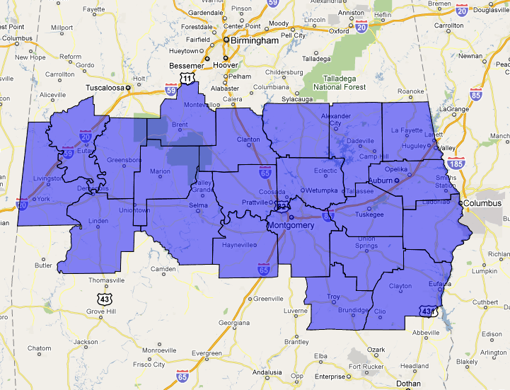
The NWS products match up nicely with our ongoing forecasts… scroll down for the afternoon discussion and Weather Xtreme video… WWUS44 KBMX 102109 WSWBMX URGENT – WINTER WEATHER MESSAGE NATIONAL WEATHER SERVICE BIRMINGHAM AL 309 PM CST WED FEB 10 2010 …LOCALLY HEAVY SNOW POSSIBLE ON FRIDAY… ALZ030>050-110515- /O.NEW.KBMX.WS.A.0001.100212T0600Z-100213T0000Z/ SUMTER-GREENE-HALE-PERRY-BIBB-CHILTON-COOSA-TALLAPOOSA-CHAMBERS- MARENGO-DALLAS-AUTAUGA-LOWNDES-ELMORE-MONTGOMERY-MACON-BULLOCK- LEE-RUSSELL-PIKE-BARBOUR- INCLUDING THE CITIES […]

Read More

Snow For Alabama Friday

Snow For Alabama Friday

| February 10, 2010 @ 3:03 pm | 6 Replies

An all new edition of the ABC 33/40 Weather Xtreme video is available in the player below. You can subscribe to the Weather Xtreme video on iTunes by clicking here. THIS AFTERNOON: Temperatures are considerably below MOS guidance; the computer models always struggle with weather extremes; guidance had highs in the low to mid 40s […]

Read More

Is it our turn?  Part 5 Wednesday

Is it our turn? Part 5 Wednesday

| February 10, 2010 @ 2:10 pm | 32 Replies

As James points out below, it looks like the largest snowfall will be in south-central Alabama, in places like Montgomery, Opp, Troy, and Jackson. Surface lows tend to follow temperature gradients, and with there having been so much cold air already this year, allowing Gulf of Mexico water temperatures to fall into the 50s out […]

Read More

Accumulation Forecast

Accumulation Forecast

| February 10, 2010 @ 12:30 pm | 82 Replies

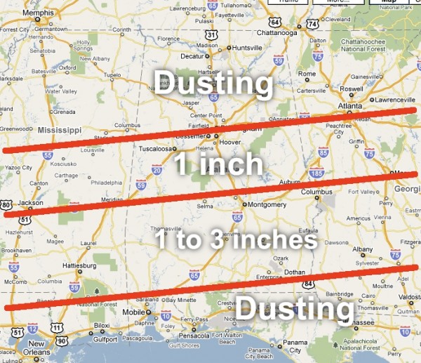
Here is a graphic that sums up my thinking on Friday’s snow event in Alabama. The ECMWF remains the favored model; the Canadian and the US models are slowly moving in that direction. I-20 will be on the northern periphery of the system, and dry air over North Alabama will keep amounts very light north […]

Read More

Mid-Morning Notes

Mid-Morning Notes

| February 10, 2010 @ 9:19 am | 114 Replies

A quick peek at the 12Z run of the NAM confirms the trend of the American models adjusting northward on our Friday surface low in the Gulf of Mexico. Extraction of the NAM shows 0.12″ of liquid for Birmingham, or around 1 inch of snow, which matches our idea for the I-20 corridor from the […]

Read More

Winter Storm Potential Friday

Winter Storm Potential Friday

| February 10, 2010 @ 6:10 am | 65 Replies

An all new edition of the ABC 33/40 Weather Xtreme video is available in the player below. You can subscribe to the Weather Xtreme video on iTunes by clicking here. THIS MORNING: Snow flurries are flying over parts of Northeast Alabama this morning; we have had reports of flurries over parts of Blount, Etowah, and […]

Read More

BMX Snow Statement

BMX Snow Statement

| February 10, 2010 @ 5:41 am | 3 Replies

SPECIAL WEATHER STATEMENT NATIONAL WEATHER SERVICE BIRMINGHAM AL 540 AM CST WED FEB 10 2010 ALZ011>015-017>050-110600- AUTAUGA-BARBOUR-BIBB-BLOUNT-BULLOCK-CALHOUN-CHAMBERS-CHEROKEE- CHILTON-CLAY-CLEBURNE-COOSA-DALLAS-ELMORE-ETOWAH-FAYETTE-GREENE-HALE- JEFFERSON-LAMAR-LEE-LOWNDES-MACON-MARENGO-MARION-MONTGOMERY-PERRY- PICKENS-PIKE-RANDOLPH-RUSSELL-SHELBY-ST CLAIR-SUMTER-TALLADEGA- TALLAPOOSA-TUSCALOOSA-WALKER-WINSTON- 540 AM CST WED FEB 10 2010 …WINTER WEATHER POTENTIAL FOR FRIDAY… OVER THE LAST COUPLE OF DAYS MUCH HAS BEEN DISCUSSED IN REGARDS TO THE POTENTIAL FOR WINTER WEATHER ON FRIDAY. AT […]

Read More