Alabama 811 | Know What's Below.

Archive for February 12th, 2010

Birmingham’s Coldest Temperature Ever

Birmingham’s Coldest Temperature Ever

| February 12, 2010 @ 10:54 pm | 12 Replies

On February 13, 1899, one of the coldest airmasses ever observed in the U.S. made it all the way to the Gulf Coast. It was 7F in New Orleans and Pensacola. Mobile dropped to a numbing -1F. The reading of -2F at Tallahassee still is the state’s coldest reading ever. Many all time state record […]

Read More

Roads “Sheets of Ice”

Roads “Sheets of Ice”

| February 12, 2010 @ 8:36 pm | 10 Replies

We cannot emphasize how dangerous the roads have become across much of Alabama tonight. John Talbot, one of our excellent Skywatchers, monitors emergency scanners across the area and reports that local Police, Fire and Emergency Responders have been slammed with calls as motor vehicle accidents have exploded in the last hour. A FEW REPORTS …Shades […]

Read More

Dangerous Road Situation Tonight

Dangerous Road Situation Tonight

| February 12, 2010 @ 7:58 pm | 9 Replies

Birmingham Police are shutting down all interstates in the city at this time due to icy conditions. There have been numerous accidents and even a person struck by a car. Etowah County has closed all roads. It is best to not be driving tonight. If you must drive, leave early, give plenty of room for […]

Read More

Black Ice

Black Ice

| February 12, 2010 @ 5:05 pm | 25 Replies

A big part of Alabama was under a blanket of snow late this afternoon. However, the snow is ending gradually from west to east and most of it will be gone by this evening. The Alabama countryside looks like a Christmas Card or a Kinkade painting! But there is a problem. Black Ice Some of […]

Read More

Snow Update – 445 pm

Snow Update – 445 pm

| February 12, 2010 @ 5:02 pm | 5 Replies

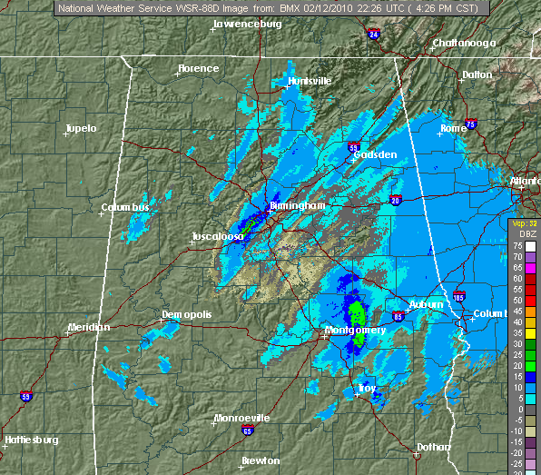
Snow looking from Bluff Creek on Warrior River Moderate snow is falling again here in Trussville, as bands wrap around the NW side of the system. This event panned out for central Alabama, but it looks like south Alabama didn’t get quite as much as we thought. We will continue to see occasional snow into […]

Read More

Looking Ahead….

Looking Ahead….

| February 12, 2010 @ 3:24 pm | 24 Replies

**No Weather Xtreme video this afternoon** We will return to the regular video production schedule tomorrow… just too much going on today. Let me say I really had a blast down in Montgomery this morning in the StormChaser; we had around 50,000 views of that stream during the morning. Simply amazing. Thanks also to John […]

Read More

South Alabama Snow…

South Alabama Snow…

| February 12, 2010 @ 2:44 pm | 5 Replies

Melba Pierce sent these photos from their plant in Thomasville in South Alabama’s Clarke County…

Read More

A Snow Day…With Snow!

A Snow Day…With Snow!

| February 12, 2010 @ 2:05 pm | 4 Replies

It’s really beautiful out there right now with snow falling steadily. It has accumulated to a depth of two inches here at my location in Trussville and there is another 45 minutes or so of snow to go here. We can see the back edge now coming through Pickens, Greene and Sumter Counties, but the […]

Read More

Snow Continues to Increase

Snow Continues to Increase

| February 12, 2010 @ 12:29 pm | 36 Replies

Snow continues to increase this afternoon across Central Alabama. In the Birmingham metro area, moderate to occasionally heavy snow now extends from southeastern Walker through western Jefferson, into northern Bibb and western Shelby County. Some heavier snow also extends from Dallas through Autauga into Chilton, Coosa and Talladega Counties. Heavier snow was building over southern […]

Read More

Special Report at 1:00

Special Report at 1:00

| February 12, 2010 @ 12:24 pm | Reply

I will be on our live stream, and our WeatherNow digital channel (33.2/40.2) at 1:00 with a special report on what you can expect for the rest of the afternoon, and over the weekend. You can access the stream from the blog… it is the only on the upper left that says “Live Radar”…

Read More

Heavier snow now moving in

Heavier snow now moving in

| February 12, 2010 @ 12:04 pm | 1 Reply

Almost 1″ of snow has already accumulated on grassy areas here in Trussville, and the heaviest snow is about to move into the Birmingham area over the next 2 hours. The upper-level disturbance will move on through this afternoon, so the heaviest snow will be between now and 3 pm in TCL and BHM, and […]

Read More

Note to Businesses and Employers

Note to Businesses and Employers

| February 12, 2010 @ 11:11 am | 14 Replies

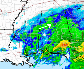
A strong disturbance moving through Mississippi has really intensified the snow across Central Alabama late this morning. The temperatures aloft are very cold up at about 5,000 feet. Now the atmosphere has moistened and the snow has increased in intensity. Snow is accumulating now on decks, grass and cars in most areas. As the snow […]

Read More

All On The Same Page Now

All On The Same Page Now

| February 12, 2010 @ 10:46 am | Reply

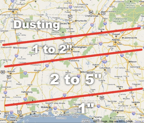
Looks like the NWS has come down on their snow totals for I-20, and are in excellent agreement with our forecast of 1-2 inches. This is the graphic we put out here yesterday, and it looks like it will work out very nicely… Still, watch for snow banding on the radar this afternoon…. some spots […]

Read More

Quick update 1035 am

Quick update 1035 am

| February 12, 2010 @ 10:34 am | Reply

See below for more details. Snow starting to accumulate here in Trussville. Temperatures have fallen rapidly since the snow began to fall about 930 am. Currently: BHM airport 32, Trussville 33, Clay 31, Hoover 34, Calera 34, Tuscaloosa 33, Jasper 32. Ground temperatures are cold…and bridges may start to become icy before noon. Drive carefully […]

Read More