

Severe Storms Possible Thursday
ANOTHER FRIGID MORNING: Here are some temperatures early this morning across the great state of Alabama…
Black Creek (just northeast of Gadsden) 26
Valley Head 28
Haleyville 29
Gadsden (Noccalula Falls) 30
Cullman 30
Fort Payne 30
Concord 30
Coker 31
Centre 31
Helena 32
Anniston 33
Tuscaloosa 34
Birmingham Airport 36
We warm up very nicely today; we reach the 67-70 degree range this afternoon with sunshine in full supply. Clouds begin to increase tomorrow as moisture returns, but the day will stay dry with a high in the upper 60s/low 70s for most places.
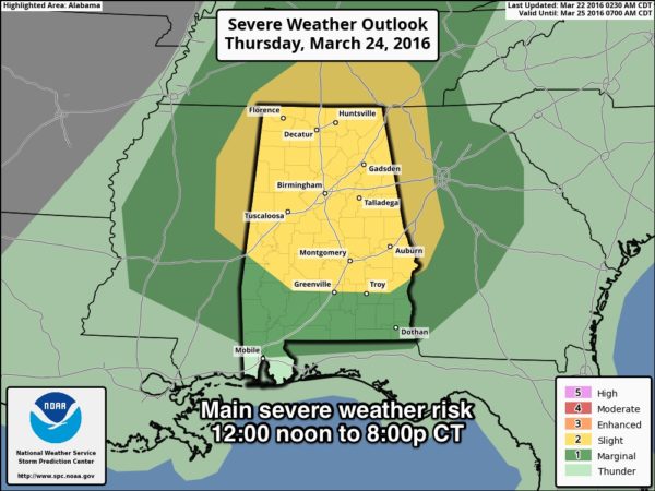
SEVERE WEATHER THREAT THURSDAY: SPC has defined a “slight risk” of severe weather for the northern two-thirds of Alabama Thursday…
A deep surface low (around 990 mb) will be over the Great Lakes, with a trailing cold front supported by a deep upper trough. Biggest limiting factor for severe storms will be instability; surface based CAPE values will struggle to rise to the 500-1000 j/kg range over North Alabama. But, dynamics are very good with a low level jet of over 50 knots, and 0-1 km storm relative helicity values in excess of 200 m2/s2.
TIMING: The primary threat of severe storms will come from 12:00 noon until 8:00 p.m. Thursday.
PLACEMENT: Highest risk of severe storms will come in the “slight risk” area over North and Central Alabama. The risk decreases over far South Alabama as upper support will be much more limited there.
MODES: The main issue will be from strong straight line winds associated with the thunderstorms, although an isolated tornado is certainly possible with the higher SRH values.
RAIN AMOUNTS: Rain totals of 1/2 to 1 inch are expected, not enough for flooding issues.
FRIDAY: The day will be sunny and cool; mid 30s are possible in colder pockets early Friday morning with potential for some scatted light frost. The high Friday afternoon will be in the mid 60s.
THE ALABAMA WEEKEND: We will continue to lean toward the European model’s dry solution for Saturday and mention just a small risk of rain, mainly for South Alabama, with a high in the low 70s. Sunday looks pretty wet statewide with periods of rain likely, along with a thunderstorm or two. Severe storms are not expected, and rain amounts Sunday should be in the 1/2 to 1 inch range. We hold in the 60s all day Sunday due to clouds and rain.
NEXT WEEK: The first half of the week looks dry with pleasant days and cool nights… then we will have a chance of showers/storms returning Thursday (March 31), we will have to monitor that one for severe potential as it gets closer. See the Weather Xtreme video for maps, graphics, and more details.
AT THE BEACH: Dry through tomorrow along the coast from Gulf Shores to Panama City Beach, but showers/storms return Thursday. Then, Friday will be dry, followed by a risk of more rain over the weekend ahead. Sea water temperatures remain very cool; only 60 degrees early this morning at the Dauphin Island Sea Lab; that will limit the air temperatures on the immediate coast. See a very detailed Gulf Coast forecast here.
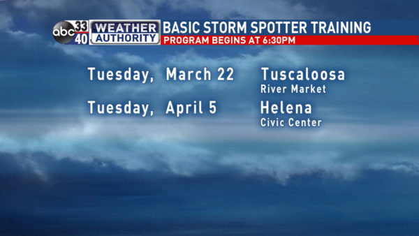
STORM SPOTTER TRAINING: We are offering basic SKYWARN training at several locations across North/Central Alabama in March, followed by the big event, Storm Spotter Xtreme on Saturday, April 9 at the BJCC from 9am to 2pm. This will feature both the basic and advanced SKYWARN classes, along with a session from Kevin Laws of the Birmingham NWS office. And, if you come, you get free admission to the Alabama International Auto Show, going on at the BJCC that same day. There is no cost and no need to register. Just show up with a curious mind. Kids 10 and older will also enjoy this if they love weather and want to learn more. Please help us make the severe weather warning process better!
We are in Tuscaloosa this evening!
WEATHER BRAINS: Don’t forget you can listen to our weekly 90 minute netcast anytime on the web, or on iTunes. This is the show all about weather featuring many familiar voices, including our meteorologists here at ABC 33/40. Scroll down for the show notes on the new episode we recorded last night.
CONNECT: You can find me on all of the major social networks…
Facebook
Twitter
Google Plus
Instagram
Look for the next Weather Xtreme video here by 4:00 this afternoon… enjoy the day!
Category: Alabama's Weather
About the Author (Author Profile)
James Spann is one of the most recognized and trusted television meteorologists in the industry. He holds the AMS CCM designation and television seals from the AMS and NWA. He is a past winner of the Broadcast Meteorologist of the Year from both professional organizations.Subscribe
If you enjoyed this article, subscribe to receive more just like it.


