

Severe Storms Likely Tomorrow
THIS AFTERNOON: As expected, today has been dry and mild across the state; the sky occasionally cloudy, but no rain. Temperatures are near 70 degrees in most places.
A dynamic weather system will bring a threat of severe storms to our tomorrow; a deep surface low will be southeast of Chicago with a trailing cold front approaching, supported by a strong upper trough. New models (the 12Z set) have come in a little slower, and with higher instability values for Alabama. The 12Z high resolution NAM model is showing a STP (Significant Tornado Parameter) value of around 4 for the Birmingham metro late tomorrow afternoon based on the better combination of instability and shear.
Here is the latest thinking…
PLACEMENT: No change in the SPC outlook for tomorrow. The standard “slight risk” of severe storms is defined for areas north of a line from Thomasville to Georgiana to Troy to Eufaula, and a “marginal risk” is in place down to the Gulf Coast.
TIMING: The overall window for severe weather is from 1:00 until 11:00 p.m. Initially, the risk will be over West Alabama, with the threat shifting slowly eastward during the afternoon and evening hours.
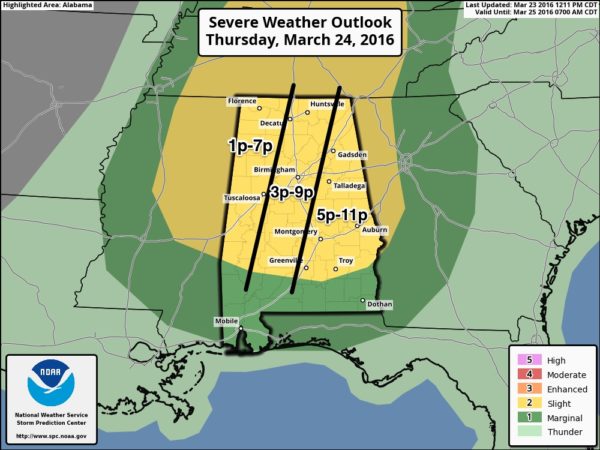
MODES: Storms tomorrow afternoon and tomorrow night will be capable of producing large hail, damaging straight line winds, and a few tornadoes. The tornado threat will decrease over far East Alabama tomorrow night.
RAIN AMOUNTS: Totals of 1/2 to 1 inch are likely, widespread flooding problems are not expected.
CALL TO ACTION: Be sure you are in a position to hear severe weather watches and warnings tomorrow afternoon into the nighttime hours; a NOAA Weather Radio and a good smart phone app like WeatherRadio by WDT are the best choices. See this post for more thoughts on what you can do to get ready.
FRIDAY: The day will be mostly sunny and a bit cooler with a high in the mid 60s. The risk of frost early Friday morning has pretty much faded; looks like most places will see a low in the 40s.
EASTER WEEKEND: Saturday should be a beautiful day, with a good supply of sunshine along with a high in the mid 70s. Clouds return Saturday night, and we will continue to forecast periods of rain Sunday, along with the chance of a thunderstorm or two. Severe storms are not expected Sunday, and it looks like the highest chance of rain will come from the late morning hours through the afternoon. Rain amounts of around 1/2 inch are likely.
NEXT WEEK: The weather looks dry and pleasant Monday through Wednesday… then showers and storms return Thursday; that system could bring another threat of strong to severe storms. See the Weather Xtreme video for maps, graphics, and more details.
AT THE BEACH: Showers and storms are likely tomorrow afternoon on the coast, followed by a dry day Friday. Rain chances will increase again over the Easter weekend… See a very detailed Gulf Coast forecast here.
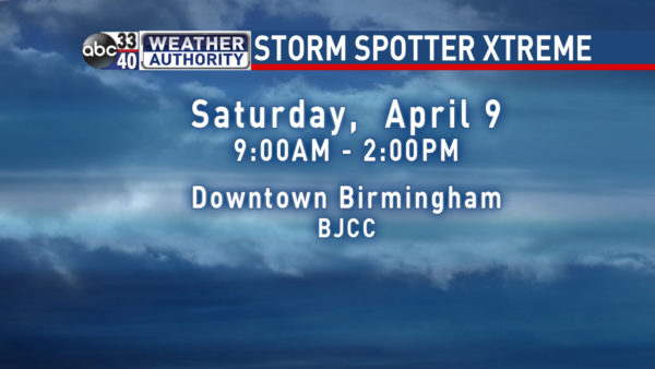
STORM SPOTTER TRAINING: Storm Spotter Xtreme is Saturday, April 9 at the BJCC from 9am to 2pm. This will feature both the basic and advanced SKYWARN classes, along with a session from Kevin Laws of the Birmingham NWS office. And, if you come, you get free admission to the Alabama International Auto Show, going on at the BJCC that same day. There is no cost and no need to register. Just show up with a curious mind. Kids 10 and older will also enjoy this if they love weather and want to learn more. Please help us make the severe weather warning process better!
WEATHER BRAINS: Don’t forget you can listen to our weekly 90 minute netcast anytime on the web, or on iTunes. This is the show all about weather featuring many familiar voices, including our meteorologists here at ABC 33/40.
CONNECT: You can find me on all of the major social networks…
Facebook
Twitter
Google Plus
Instagram
I enjoyed seeing 2nd graders at Meadow View Elementary in Alabaster, and the 3rd graders at Chelsea Park Elementary today… be looking for them on the Pepsi KIDCAM today at 5:00 and 6:00 on ABC 33/40 News! The next Weather Xtreme video will be posted here by 7:00 a.m. tomorrow…
Category: Alabama's Weather
About the Author (Author Profile)
James Spann is one of the most recognized and trusted television meteorologists in the industry. He holds the AMS CCM designation and television seals from the AMS and NWA. He is a past winner of the Broadcast Meteorologist of the Year from both professional organizations.Subscribe
If you enjoyed this article, subscribe to receive more just like it.


