

Strong/Severe Storms Later Today
ACTIVE WEATHER DAY: Things are quiet across Alabama early this morning, but we continue to watch thunderstorms off to the west, and we will have a setup for strong to severe storms around here later today and early tonight.
A deep surface low will be southeast of Chicago this afternoon, with a trailing cold front supported by a deep upper trough. Instability values are expected to rise, exceeding 1000 j/kg (CAPE) in spots this afternoon. Shear values suggest a few rotating storms are possible, especially over the northern half of the state.
PLACEMENT: SPC has defined the standard “slight risk” of severe weather today for areas north of a line from Chatom to Greenville to Roanoke, and a “marginal risk” to the south, all the way to the Gulf Coast.
TIMING: We have adjusted the times again to reflect a severe weather window for Alabama from 12:00 noon to 8:00 p.m.
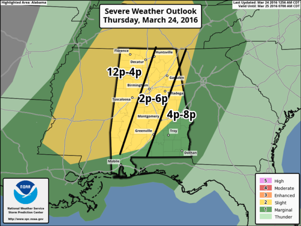
The severe weather threat will begin in West Alabama early this afternoon, with the risk shifting slowly eastward.
MODES: Storms later today will be capable of producing hail, strong/damaging winds, and a few tornadoes.
RAIN AMOUNTS: Totals should be in the 1/2 to 1 inch range; flooding on a widespread basis is not expected.
CALL TO ACTION: Be sure you can hear severe weather watches and warnings this afternoon if they are needed, know where you are going if you happen to fall under a tornado warning polygon, and have a readiness kit in your safe place, including helmets. See this post on getting ready for severe weather in Alabama.
Remember, this is the core of the spring tornado season in our state, so events like this are pretty common. Just be prepared and we will get through the day just fine.
TOMORROW/SATURDAY: These two days will be dry. Lingering clouds early tomorrow will give way to afternoon sunshine with a high in the mid 60s. Saturday will be mostly sunny and warmer with a high in the mid 70s.
EASTER SUNDAY: No doubt we will have to deal with rain at times. Highest risk of rain comes from late morning through the afternoon, but we can’t guarantee early morning Easter sunrise services will be dry. Some thunder is possible Sunday, but severe weather is not expected. We will have a much better handle on timing once we get today’s system out of here.
NEXT WEEK: Dry, pleasant weather is the story Monday and Tuesday; showers and storms return Wednesday night into Thursday. Some chance this could be another setup for strong or severe storms… see the Weather Xtreme video for maps, graphics, and more details.
AT THE BEACH: Showers and storms are likely on the coast from Gulf Shores over to Panama City Beach later today and tomorrow… but tomorrow will be dry with a sunny sky. Then, the chance of rain returns over the weekend… See a very detailed Gulf Coast forecast here.
STORM SPOTTER TRAINING: Storm Spotter Xtreme is Saturday, April 9 at the BJCC from 9am to 2pm. This will feature both the basic and advanced SKYWARN classes, along with a session from Kevin Laws of the Birmingham NWS office. And, if you come, you get free admission to the Alabama International Auto Show, going on at the BJCC that same day. There is no cost and no need to register. Just show up with a curious mind. Kids 10 and older will also enjoy this if they love weather and want to learn more. Please help us make the severe weather warning process better!
WEATHER BRAINS: Don’t forget you can listen to our weekly 90 minute netcast anytime on the web, or on iTunes. This is the show all about weather featuring many familiar voices, including our meteorologists here at ABC 33/40.
CONNECT: You can find me on all of the major social networks…
Facebook
Twitter
Google Plus
Instagram
I have a weather program this morning at Spring Valley School… stay tuned to the blog for updates on the severe weather situation throughout the day!
Category: Alabama's Weather
About the Author (Author Profile)
James Spann is one of the most recognized and trusted television meteorologists in the industry. He holds the AMS CCM designation and television seals from the AMS and NWA. He is a past winner of the Broadcast Meteorologist of the Year from both professional organizations.Subscribe
If you enjoyed this article, subscribe to receive more just like it.


