

Still Monitoring Tornado Threat for Late This Afternoon/This Evening
A Tornado Watch has been issued until 7:00 PM CDT for areas in extreme southern Alabama, the western panhandle of Florida, and extreme southeastern Mississippi. Counties in Alabama include Baldwin, Butler, Coffee, Conecuh, Covington, Crenshaw, Escambia, Geneva, Mobile, and Monroe.
SEVERE WEATHER THREAT UPDATE
We continue to monitor developments across the Southeast U.S. to pin down our severe weather threat across Central Alabama. Our first round of non-severe storms has moved through the Tuscaloosa/Birmingham areas and has weakened a bit.
Only 0.08 inches of rain at the Birmingham Airport through 12:17 p.m.
The second line of storms has crossed into western Franklin, western marion and Lamar Counties. Those storms are not severe either. They will spread across the North Central part of the state between now and 4 p.m.
Our cold front now extends from Blytheville TN to Pine Bluff Arkansas to just east of Eldorado AR to Fort Polk and Lake Charles in Louisiana. We still expect to see strong to severe storms form near the Mississippi/Alabama border after 4 p.m. ahead of this front. There are signs on the HRRR that there could be sufficient instability and low level shear for these storms be take on a cellular look for a couple of hours as they traverse West Central Alabama from Marion to Sumter Counties and move eastward. They would affect areas from Walker to Tuscaloosa Counties around 5 p.m., and Cullman and Jefferson around 7 p.m.
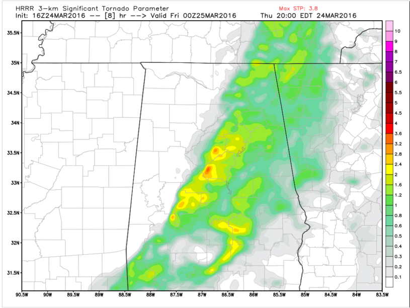
SIGTOR values at 7 p.m. CDT this evening. Values over 1 indicate possibility of EF2 or greater tornadoes. The higher the value, the greater the chance.
Significant Tornado Parameter Values from the HRRR model late this afternoon are still quite impressive. Look at these values from the latest run for 7 p.m. CDT tonight. It shows STP values >2 over a wide part of the I-59 Corridor. This could suggest a couple of significant tornadoes are possible as a sweet spot of instability (CAPE values >=1500 joules) and low level helicity (over 400 m2/s2 of 0-1 km SRH).
IF THIS VERIFIES…
We could deal with a couple of significant tornadoes late this afternoon and early this evening. Pay close attention to later weather information and have a reliable way to receive warnings. Be aware of where you will be tonight and what you will be doing, so you can have a shelter plan it a warning is issued.
COLUMBUS MS RADAR UPDATE
The Columbus MS NEXRAD has been down since Saturday. The parts should arrive and be installed later today, but the earliest the radar will be back up and running will be late this afternoon. The loss of the radar gives some degradation to radar coverage over Northeast Mississippi and Northwest Alabama, but the Birmingham, Hytop and Memphis radars will be covering.
THE WEEKEND
After the threat has passed tonight, decent conditions are in store for Friday and Saturday. Friday, skies will begin to clear out during the late morning to early afternoon hours, with highs reaching the mid 60s. Saturday will be sunny and warmer, with highs reaching the mid 70s. Unfortunately, rain is in the forecast for Easter Sunday. The rain may hold off enough until after early morning services are complete. After that, rain and a few claps of thunder is expected, with highs reaching the upper 60s to the lower 70s.
Category: Alabama's Weather, Severe Weather
About the Author (Author Profile)
Bill Murray is the President of The Weather Factory. He is the site's official weather historian and a weekend forecaster. He also anchors the site's severe weather coverage. Bill Murray is the proud holder of National Weather Association Digital Seal #0001 @wxhistorianSubscribe
If you enjoyed this article, subscribe to receive more just like it.


