

One More Delightful Day
SPECTACULAR SPRING AFTERNOON: Hard to find a cloud in the sky this afternoon; temperatures are mostly in the 60s across North/Central Alabama. Tonight will be clear and cool with a low in the 40-43 degree range for most; some colder spots could see upper 30s early tomorrow morning.
Tomorrow will be another fine spring day with ample sunshine and a warmer afternoon; the high will be at or just over 70 degrees for most.
Clouds will increase Wednesday, and showers could reach West Alabama by afternoon as another storm system approaches from the west.
STRONG STORM/HEAVY RAIN POTENTIAL: Rain and storms are likely Wednesday night and Thursday as as cold moving cold front approaches from the west, trailing from a deep upper low around the Great Lakes. Rain becomes widespread across the state Wednesday night, and for now the severe weather potential then looks rather low. But, on Thursday, we could see a break from the rain during the morning hours, and the air becomes unstable by afternoon with surface based CAPE values rising to near 2,000 j/kg over Northwest Alabama.
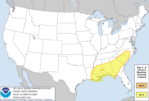
The main threat of strong/severe storms will come Thursday afternoon, but it seems like parameters are a little out of phase with the highest instability to the west, and the better dynamics to the northeast. But, this could easily change as we get closer to the event. SPC maintains a risk of severe storms Thursday (Day 4) over the southern two-thirds of the state, generally along and south of I-20. This will probably be adjusted tomorrow.
FRIDAY: We will forecast clearing, breezy, and cooler weather for the state Friday; some North Alabama communities will hold in the 50s all day.
THE ALABAMA WEEKEND: Dry air means sunshine in full supply both days, but nights will be cold. The low early Saturday will be in the 38-44 degree range, but Sunday will be a bit colder, with mid to upper 30s in many places. And, with a clear sky and light wind, some scattered light frost is certainly possible. Growers will need to monitor temperatures both mornings.
The high Saturday will be in the mid 60s, followed by upper 60s Sunday.
NEXT WEEK: Dry weather continues for the first half of next week with a gradual warming trend… see the Weather Xtreme video for maps, graphics, and more details.
AT THE BEACH: Tomorrow will be mostly sunny on the coast from Gulf Shores over to Panama City Beach, but clouds increase Wednesday, and occasional showers and storms are likely Wednesday night through Friday. See a very detailed Gulf Coast forecast here.
WEATHER BRAINS: Don’t forget you can listen to our weekly 90 minute netcast anytime on the web, or on iTunes. This is the show all about weather featuring many familiar voices, including our meteorologists here at ABC 33/40. We will produce this week’s show tonight at 8:30 CT… you can watch it here.
CONNECT: You can find me on all of the major social networks…
Facebook
Twitter
Google Plus
Instagram
I enjoyed seeing a good crowd at the Pinson Public Library this morning… look for the next Weather Xtreme video here by 7:00 a.m. tomorrow…
Category: Alabama's Weather
About the Author (Author Profile)
James Spann is one of the most recognized and trusted television meteorologists in the industry. He holds the AMS CCM designation and television seals from the AMS and NWA. He is a past winner of the Broadcast Meteorologist of the Year from both professional organizations.Subscribe
If you enjoyed this article, subscribe to receive more just like it.


