

Volatile Atmosphere Over Alabama
**No afternoon Weather Xtreme video today**
MIDDAY LULL: As expected, we are getting a nice break from the rain this afternoon, and with some sunshine temperatures are rising through the 70s, making for an unstable atmosphere.
TO THE WEST: A new tornado watch has just been issued for parts of Arkansas and Mississippi until 10:00 p.m..

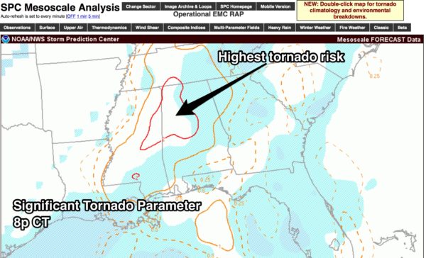
Showers and storms will increase rapidly in coming hours across Mississippi and Alabama, and parameters still favor severe storms with heavy rain. Below is the forecast STP (Significant Tornado Parameter) at 8:00 p.m.. showing the highest risk of tornadoes…
Here is our projected timing…
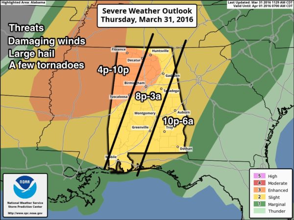
All modes of severe storms will be possible tonight with the stronger storms, including hail, damaging winds, and a few tornadoes. A strong tornado is not out of the question in the “enhanced risk” from Birmingham north and west.
FLASH FLOOD WATCH: It remains in effect tonight; additional rain amounts of 2 inches are possible.
CALL TO ACTION: Be sure you can hear severe weather watches and warnings, and know where you are going if you come under a tornado warning polygon. And, be sure and have a readiness kit in that “safe place”, including helmets. For additional information, including thoughts on apps for your phone, please see this post.
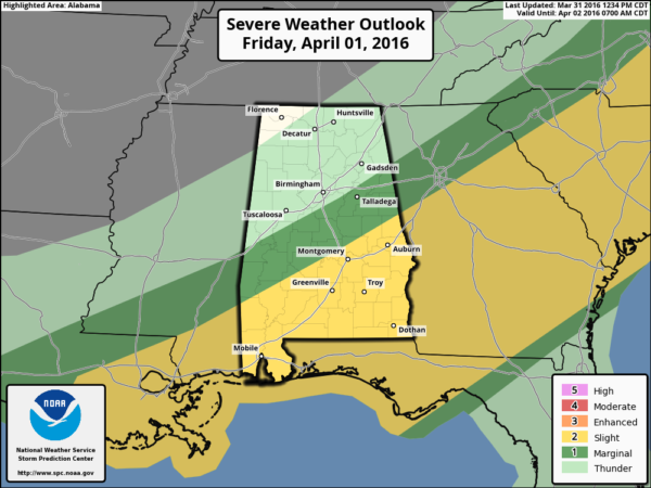
TOMORROW: Still a mystery to some degree with model madness, but no doubt the highest threat of severe weather will shift down into South Alabama.
We will hang on to the chance of a few lingering showers tomorrow across Central Alabama; the day will be mostly cloudy with a high in the 70s.
THE ALABAMA WEEKEND: Sunny weather is the story Saturday and Sunday with chilly nights; we will get down into the upper 30s early Sunday morning, and some of the valleys and colder spots could be close to freezing with frost. Growers will need to monitor temperatures.
NEXT WEEK: We will be dry Monday through Tuesday; the new GFS run (12Z) now shows a band of showers moving through the state Wednesday afternoon and Wednesday night, followed by sharply colder air Thursday and Friday. Looks like another frost/freeze threat Friday and Saturday morning. Never plant anything that will be harmed by frost or a freeze before April 15 around here.
AT THE BEACH: Showers and storms are likely on the coast from Panama City Beach over to Gulf Shores through tomorrow, but the weekend will be drier. See a very detailed Gulf Coast forecast here.
STORM SPOTTER TRAINING: Storm Spotter Xtreme is coming up Saturday, April 9 at the BJCC from 9am to 2pm. This will feature both the basic and advanced SKYWARN classes, along with a session from Kevin Laws of the Birmingham NWS office. And, if you come, you get free admission to the Alabama International Auto Show, going on at the BJCC that same day. There is no cost and no need to register. Just show up with a curious mind. Kids 10 and older will also enjoy this if they love weather and want to learn more. Please help us make the severe weather warning process better!
WEATHER BRAINS: Don’t forget you can listen to our weekly 90 minute netcast anytime on the web, or on iTunes. This is the show all about weather featuring many familiar voices, including our meteorologists here at ABC 33/40.
CONNECT: You can find me on all of the major social networks…
Facebook
Twitter
Google Plus
Instagram
Stay tuned to the blog for frequent updates tonight as storms blow through the state. The next Weather Xtreme video will be posted here by 7:00 a.m. tomorrow…
Category: Alabama's Weather
About the Author (Author Profile)
James Spann is one of the most recognized and trusted television meteorologists in the industry. He holds the AMS CCM designation and television seals from the AMS and NWA. He is a past winner of the Broadcast Meteorologist of the Year from both professional organizations.Subscribe
If you enjoyed this article, subscribe to receive more just like it.


