

Here is an Update on the Alabama Weather Situation at 445 p.m.
You knew it was serious when J.B. started his NOAA Weatheradio updates with “Here is an update on the Alabama Weather Situation…”
Temperatures at this moment range from the upper 60s to lower 70s north of the I-20 corridor, with dewpoints in lower to mid 60s. South of I-20, you can find temps in the middle to upper 70s, with dewpoints in the mid to upper 60s.
A Flash Flood Watch continues in effect for the entire state of Alabama. Flash Flood Warnings are currently in effect for Geneva and Houston counties until 5:30 PM CDT. A Tornado Watch continues in effect for northern Mississippi and western Tennessee Until 10 PM CDT. A Severe Thunderstorm Watch continues in effect for counties in central Tennessee, northern Arkansas, and southeastern Arkansas until 10 PM CDT.
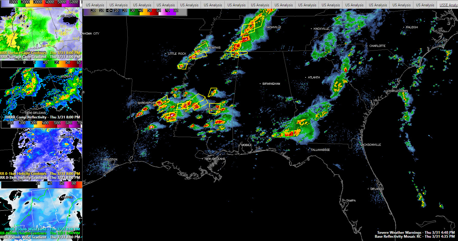
Left side panels show HRRR model output at 8 p.m. Large panel shows curent radar and warnings (severe thunderstorm yellow, tornado red).
ACTIVE ALL AROUND US
Severe thunderstorms are firing like a string of firecrackers in the unstable air to the north, west and southwest of Alabama. Storms have become severe along and south of I-20 across northern Louisiana and South Central Mississippi.
The storm approaching Tallulah LA, just across the Mississippi River from Vicksburg has produced 1” hail. Radar indicated the hail might have reached tennis ball size in spots. This same storm knocked down trees in Franklin Parish as well.
A severe storm is about to cross I-20 west of Meridian. This storm will eventually affect Sumter County, Alabama between 6-7 p.m.
Another severe storm will cross I-59 near Laurel within the hour and a new warning just went up for the area around Kosciusko MS.
Severe storms are approaching the Memphis area. Several severe storms are over southern Tennessee. A tornado warning is in effect northeast of Henderson TN, where a funnel cloud was sighted. Severe storms will be approaching Nashville in just over an hour.
There are severe thunderstorm warnings as far north of Frankfort KY.
Tornado watches now cover southern Tennessee and much of Mississippi. Severe thunderstorm watches cover northern Louisiana, southeastern Arkansas and Middle Tennessee and southern Kentucky.
CLOSER TO HOME
Currently, most of the state is relatively free from rain, except for the extreme southeastern part of the state. A hefty thunderstorm is pushing its way east through Geneva and Houston counties. This storm has a history of knocking power lines down earlier in the western part of Geneva county. It has also produced large rain totals, as the Double Creek Bridge MESONET site 4 miles east-northeast on Samson in Geneva County reported a total of 2.72 inches so far.
MOVING THROUGH THE NEXT SEVERAL HOURS
The storms over northern Louisiana and South Central Mississippi will move into Alabama between 7-8 p.m. They will encounter a moderately unstable airmass with CAPE values between 1,000-1,500 joules/kg. So the storms should remain strong.
Speed shear between 0-6 km should be running 40-45 knots then, which is supportive of organized storms.
Low level helicity should be between 200-300 m2/s2, which is indicative of a tornado threat.
A developing 850 mb jet will enhance the damaging wind threat. Large hail is a threat as well, especially over Northwest Alabama.
The storms should reach Tuscaloosa between 8-9 p.m. and Birmingham between 9-10 p.m. They will likely congeal into a long squall line around midnight in the I-59 Corridor that will slowly sink southward in the hours after midnight.
The good news is that the severe weather overnight should end when the line of storms drops south of your location as the instability will have been exhausted by then.
SPC RISKS:
A slight risk now covers the entire state overnight. An enhanced risk, one level above slight, covers areas northwest of a line from Livingston to Sylacauga to Talladega to Arab to north of Florence. Cities in the enhanced risk area include Birmingham, Tuscaloosa, Alabaster, Oneonta, Cullman, Jasper, Hamilton, Fayette, Vernon, Carrolton and Eutaw.
Category: Alabama's Weather, Severe Weather
About the Author (Author Profile)
Bill Murray is the President of The Weather Factory. He is the site's official weather historian and a weekend forecaster. He also anchors the site's severe weather coverage. Bill Murray is the proud holder of National Weather Association Digital Seal #0001 @wxhistorianSubscribe
If you enjoyed this article, subscribe to receive more just like it.


