

Severe Weather Risk Today – South Alabama
RADAR CHECK: There is a broad mass of showers and storms early this morning from near Pensacola to Atlanta…
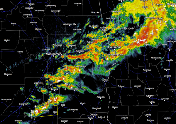
We note Covington County in far South Alabama is under a severe thunderstorm warning, issued at 5:41.
The severe weather risk today is primarily for the southern half of the state; SPC has the standard “slight risk” defined south of a line from Thomasville to Prattville to Lafayette…
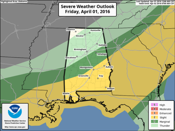
The main threat today will come from straight line thunderstorm winds and some hail. We should also mention a flash flood watch remains in effect today for most of the state, except the Tennessee Valley.
Showers and storms this morning will be mostly confined to South Alabama, but high resolution model data shows the rain mass moving northward, reaching I-20 late this afternoon. Some rain is likely for places like Birmingham, Anniston, and Tuscaloosa in the 3pm – 10pm time frame. No severe storms, but some thunder is possible. The day will be mostly cloudy with a high in the 70s.
THE WEEKEND: Dry air returns, and we expect sunshine in full supply tomorrow and Sunday with a high both days in the mid 60s. Sunday morning will be pretty cold with a low in the 37-43 degree range; colder valleys will see low to mid 30s with some frost. Growers beware.
NEXT WEEK: Dry weather continues Monday and Tuesday with pleasant afternoons and cool nights. Next chance of rain comes Wednesday night into Thursday morning thanks to a passing cold front; some thunderstorms are possible, but at this time the risk of severe weather looks low. Then, a pretty cool airmass will follow, and the GFS continues to suggest we will see lows by Friday morning (April 8) in the 30-35 degree range. Another situation growers and gardeners will need to monitor in coming days. See the Weather Xtreme video for maps, graphics, and more details.
AT THE BEACH: Showers/storms are likely today, but the weather improves over the weekend with returning sunshine. Dry weather holds into early next week… See a very detailed Gulf Coast forecast here.
STORM SPOTTER TRAINING: Storm Spotter Xtreme is coming up Saturday, April 9 at the BJCC from 9am to 2pm. This will feature both the basic and advanced SKYWARN classes, along with a session from Kevin Laws of the Birmingham NWS office. And, if you come, you get free admission to the Alabama International Auto Show, going on at the BJCC that same day. There is no cost and no need to register. Just show up with a curious mind. Kids 10 and older will also enjoy this if they love weather and want to learn more. Please help us make the severe weather warning process better!
We will also offer a basic class at the Helena Civic Center next Tuesday (April 5) at 6:30.
WEATHER BRAINS: Don’t forget you can listen to our weekly 90 minute netcast anytime on the web, or on iTunes. This is the show all about weather featuring many familiar voices, including our meteorologists here at ABC 33/40.
CONNECT: You can find me on all of the major social networks…
Facebook
Twitter
Google Plus
Instagram
I have a weather program this morning at Englewood Elementary in Tuscaloosa… look for the next Weather Xtreme video here by 4:00 this afternoon. Enjoy the day!
Category: Alabama's Weather
About the Author (Author Profile)
James Spann is one of the most recognized and trusted television meteorologists in the industry. He holds the AMS CCM designation and television seals from the AMS and NWA. He is a past winner of the Broadcast Meteorologist of the Year from both professional organizations.Subscribe
If you enjoyed this article, subscribe to receive more just like it.


