

Strong Storms Late Tomorrow
CLOUDLESS SKY: Another fine spring day with a sunny sky, and temperatures in the 60s. But, some changes area ahead for the mid-week period.
STRONG STORMS POSSIBLE: A deep surface low will be over the Great Lakes tomorrow, with a trailing cold front. Showers and storms will advance into our state tomorrow afternoon, and some of those storms could be fairly strong. SPC maintains a “marginal risk” of severe storms over about the northern half of the state…
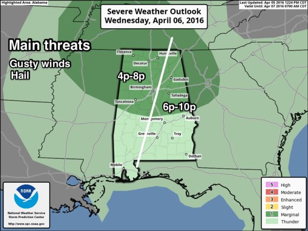
Wind fields, instability, and shear values are sufficient to support organized storms, but also suggest this won’t be a major threat. But, this is early April and we always need to watch for surprises. Main window for strong storms will come from 4:00 until 10:00… and the prime threats will come from gusty thunderstorm winds and hail.
We should also mention pressure gradient winds (not related to thunderstorms) will rise to 15-25 mph tomorrow afternoon, with gusts over 30 mph at times. The high tomorrow will be close to 70 degrees.
THURSDAY/FRIDAY: Thursday will be mostly sunny and pleasant with a high in the low 70s, then a cooling trend begins Friday with the high dropping into the mid 60s. The air stay dry, and Friday’s sky will feature a good supply of sunshine.
THE ALABAMA WEEKEND: Cold nights will headline the forecast; we expect temperatures to drop into the 30s both Saturday and Sunday morning. Highest risk of frost, and a freeze for colder spots, will come early Sunday when the wind will be near calm. Growers and gardeners will need to monitor temperature forecasts in coming days.
The air will stay dry, and we expect sunshine in full supply both days. The high Saturday will be around 60, followed by upper 60s Sunday.
NEXT WEEK: Dry weather continues Monday; the next storm system arrives Tuesday with a chance of showers and thunderstorms. New model guidance suggests this won’t be a big severe weather threat, but we all know that could change in coming days. See the Weather Xtreme video for maps, graphics, and more details.
AT THE BEACH: Generally dry and pleasant weather is the story on the coast from Gulf Shores over to Panama City Beach through early next week; the exception is tomorrow night when showers and storms are possible. Highs mostly in the 70s… See a very detailed Gulf Coast forecast here.
STORM SPOTTER TRAINING TONIGHT: We have a basic storm spotting class at the Helena Community Center in Shelby County this evening at 6:30.
And, Storm Spotter Xtreme is coming up this Saturday, April 9 at the BJCC from 9am to 2pm. This will feature both the basic and advanced SKYWARN classes, along with a session from Kevin Laws of the Birmingham NWS office. And, if you come, you get free admission to the Alabama International Auto Show, going on at the BJCC that same day. There is no cost and no need to register. Just show up with a curious mind. Kids 10 and older will also enjoy this if they love weather and want to learn more. Please help us make the severe weather warning process better!
WEATHER BRAINS: Don’t forget you can listen to our weekly 90 minute netcast anytime on the web, or on iTunes. This is the show all about weather featuring many familiar voices, including our meteorologists here at ABC 33/40.
CONNECT: You can find me on all of the major social networks…
Facebook
Twitter
Google Plus
Instagram
I had a great time today visiting with the students at Hueytown Elementary… be looking for them on the Pepsi KIDCAM today at 5:00 on ABC 33/40 News! The next Weather Xtreme video will be posted here by 7:00 a.m. tomorrow…
Category: Alabama's Weather
About the Author (Author Profile)
James Spann is one of the most recognized and trusted television meteorologists in the industry. He holds the AMS CCM designation and television seals from the AMS and NWA. He is a past winner of the Broadcast Meteorologist of the Year from both professional organizations.Subscribe
If you enjoyed this article, subscribe to receive more just like it.


