

A Few Strong Storms Late This Afternoon
BECOMING WINDY LATER TODAY: Most of Alabama is under a “wind advisory”… pressure gradient winds will ramp up this afternoon, out of the south averaging 15-25 mph, with gusts to 30 mph. Temperatures will rise from the 40s early this morning into the low 70s this afternoon, and clouds will gradually increase ahead of an approaching cold front.
A FEW STRONG STORMS: SPC maintains a “marginal risk” of severe storms late this afternoon and tonight for about the northern half of the state…
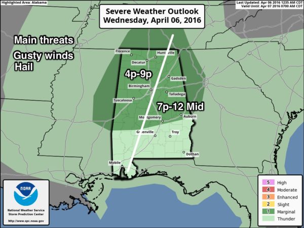
The main limiting factor will be the instability; in fact the HRRR shows dew points still in the 40s this evening, and very little surface based instability. But, we will still watch for strong storms that could produce gusty winds and some hail as they pass through. The overall severe weather threat is pretty low.
Rain amounts for most communities should be 1/2 inch or less, and the rain should be out of the northern half of the state by midnight.
TOMORROW: Dry air returns, and it will be a nice day with ample sunshine and a high in the low 70s.
FRIDAY AND THE WEEKEND: Cooler air blows in here Friday, and we will experience cold mornings over the weekend. The low early Saturday will be in the 38-41 degree range, but Sunday will be colder with 30s likely. The wind will near calm early Sunday, meaning a chance of scattered frost, and a freeze for colder valleys. Growers and gardeners will need to monitor temperature forecasts, especially Sunday morning.
The air will remain dry, do we will forecast sunny days and fair nights over the weekend; the high Saturday will be in the low 60s, followed by upper 60s Sunday.
NEXT WEEK: The weather on Monday will stay dry, but showers and storms returns Tuesday. The latest global model data shows little upper upper support and no real significant risk of severe storms. And, a wave forms on the front keeping the chance of rain and storms going into Wednesday. See the Weather Xtreme video for maps, graphics, and more details.
AT THE BEACH: A few showers and storms are possible tonight on the coast from Gulf Shores over to Panama City Beach, otherwise mostly sunny days and fair nights through early next week with mild afternoons and cool nights. See a very detailed Gulf Coast forecast here.
STORM SPOTTER TRAINING: Storm Spotter Xtreme is coming up this Saturday at the BJCC from 9am to 2pm. This will feature both the basic and advanced SKYWARN classes, along with a session from Kevin Laws of the Birmingham NWS office. And, if you come, you get free admission to the Alabama International Auto Show, going on at the BJCC that same day. There is no cost and no need to register. Just show up with a curious mind. Kids 10 and older will also enjoy this if they love weather and want to learn more. Please help us make the severe weather warning process better!
WEATHER BRAINS: Don’t forget you can listen to our weekly 90 minute netcast anytime on the web, or on iTunes. This is the show all about weather featuring many familiar voices, including our meteorologists here at ABC 33/40.
CONNECT: You can find me on all of the major social networks…
Facebook
Twitter
Google Plus
Instagram
I have weather programs today at Children’s of Alabama in Birmingham, and Greystone Elementary in Hoover. Be looking for the next Weather Xtreme video here by 4:00 this afternoon… enjoy the day!
Category: Alabama's Weather
About the Author (Author Profile)
James Spann is one of the most recognized and trusted television meteorologists in the industry. He holds the AMS CCM designation and television seals from the AMS and NWA. He is a past winner of the Broadcast Meteorologist of the Year from both professional organizations.Subscribe
If you enjoyed this article, subscribe to receive more just like it.


