

Strong Storms Early Tonight
RADAR CHECK: Nothing on radar across Alabama as I write this shortly before 3:00, but a band of showers and storms is passing through Memphis…
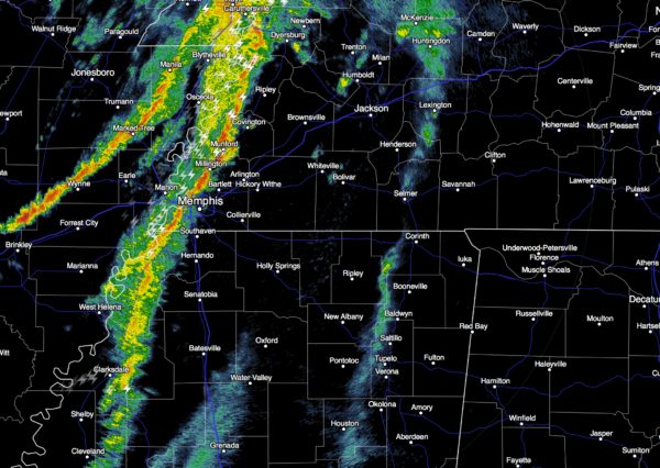
This activity will scoot through North Alabama early tonight, and they could be fairly strong with potential for gusty straight line winds and some small hail. SPC now has North Alabama under a “slight risk” of severe weather for this evening…
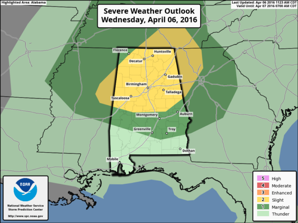
The biggest limiting factor for severe weather is the lack of instability, dew points across North Alabama remain in the 40s and 50s; you really need those up in the 60s for big severe weather issues this time of the year. Bottom line is that this is a low end severe weather threat through about 10:00 p.m.
TOMORROW: A nice day as dry air returns; we expect a good supply of sunshine with a high in the low 70s.
FRIDAY AND THE WEEKEND: Dry weather continues with sunny days and clear nights, but the weather will be cooler. By Saturday many North Alabama communities won’t get out of the 50s, and we will also be dealing with cold mornings. Saturday’s early morning low will be in the 38-42 degree range, with mid to upper 30s Sunday. The wind will be close to calm early Sunday with potential for frost, and a freeze for colder pockets. Growers and gardeners will need to keep a close eye on temperature forecasts.
A warming trend begins Sunday afternoon with a high around 70 degrees.
NEXT WEEK: The weather stays dry Monday, but showers and storms return Tuesday and Wednesday. For now this event doesn’t look like a severe weather situation; see the Weather Xtreme video for maps, graphics, and more details.
AT THE BEACH: Mostly sunny days, fair nights on the coast through Monday from Gulf Shores over to Panama City Beach. Highs in the 70s, except for upper 60s on the immediate coast. The sea water temperature early this afternoon at the Dauphin Island Sea Lab is 68 degrees. See a very detailed Gulf Coast forecast here.
STORM SPOTTER TRAINING: Storm Spotter Xtreme is coming up this Saturday, April 9 at the BJCC from 9am to 2pm. This will feature both the basic and advanced SKYWARN classes, along with a session from Kevin Laws of the Birmingham NWS office. And, if you come, you get free admission to the Alabama International Auto Show, going on at the BJCC that same day. There is no cost and no need to register. Just show up with a curious mind. Kids 10 and older will also enjoy this if they love weather and want to learn more. Please help us make the severe weather warning process better!
WEATHER BRAINS: Don’t forget you can listen to our weekly 90 minute netcast anytime on the web, or on iTunes. This is the show all about weather featuring many familiar voices, including our meteorologists here at ABC 33/40.
CONNECT: You can find me on all of the major social networks…
Facebook
Twitter
Google Plus
Instagram
Look for the next Weather Xtreme video here by 7:00 a.m. tomorrow…
Category: Alabama's Weather
About the Author (Author Profile)
James Spann is one of the most recognized and trusted television meteorologists in the industry. He holds the AMS CCM designation and television seals from the AMS and NWA. He is a past winner of the Broadcast Meteorologist of the Year from both professional organizations.Subscribe
If you enjoyed this article, subscribe to receive more just like it.


