

Rain Returns To Alabama Tonight
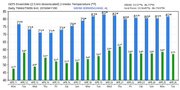
WET WEATHER AHEAD: After a delightful weekend, clouds return to Alabama today; most communities will see a high in the low to mid 70s this afternoon. West of the state, active weather is likely; there is an “enhanced risk” of severe storms around the Ark-La-Tex region.
While some rain could reach West Alabama this afternoon, showers and storms will become widespread tonight. There is a “marginal risk” of severe storms for extreme West Alabama after midnight, but the overall severe weather threat looks low with the main upper support well to the north, and very little surface based instability.
A surface low will move right through North Alabama, and it should be a good soaking, with rain amounts of around one inch likely.
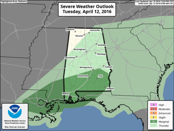
TOMORROW: Showers and storms should end during the morning, with most of the activity shifting down into South Alabama by afternoon, where SPC has a “marginal risk” of severe storms defined.
The high tomorrow afternoon will be close to 70, and we might see a few intervals of sun late in the day.
WEDNESDAY/THURSDAY: The surface front will be stationary over South Alabama, and with a wave of low pressure forming along the front, we will need to mention some risk of showers on these two days. Nothing especially heavy or widespread, but just understand a shower is possible from time to time. The sky will feature more clouds than sun, and the highs should be in the 68-72 degree range.
FRIDAY AND THE WEEKEND: The weather looks very nice, with mostly sunny days and clear nights. The high Friday will be in the low 70s, followed by mid to upper 70s this weekend.
NEXT WEEK: Dry weather continues Monday and Tuesday, followed by a chance of showers and thunderstorms Wednesday with an approaching upper trough. A good chance we see low 80s early in the week… see the Weather Xtreme video for maps, graphics, and more details.
AT THE BEACH: The weather on the Gulf Coast this week from Panama City Beach over to Gulf Shores will be unsettled; very little sunshine through Friday with some risk of showers and storms on a daily basis. But, the weekend looks great with sunshine back in full force Saturday and Sunday. Highs will remain mostly in the 70s; the sea water temperature early this morning at the Dauphin Island Sea Lab is 68 degrees. See a very detailed Gulf Coast forecast here.
WEATHER BRAINS: Don’t forget you can listen to our weekly 90 minute netcast anytime on the web, or on iTunes. This is the show all about weather featuring many familiar voices, including our meteorologists here at ABC 33/40. We will produce this week’s show tonight at 8:30 CT… you can watch it right here.
CONNECT: You can find me on all of the major social networks…
Facebook
Twitter
Google Plus
Instagram
I have a weather program this morning at Elvin Hill Elementary in Columbiana… be looking for the next Weather Xtreme video here by 4:00 this afternoon. Enjoy the day!
Category: Alabama's Weather
About the Author (Author Profile)
James Spann is one of the most recognized and trusted television meteorologists in the industry. He holds the AMS CCM designation and television seals from the AMS and NWA. He is a past winner of the Broadcast Meteorologist of the Year from both professional organizations.Subscribe
If you enjoyed this article, subscribe to receive more just like it.


