

Several Days of Dry Weather
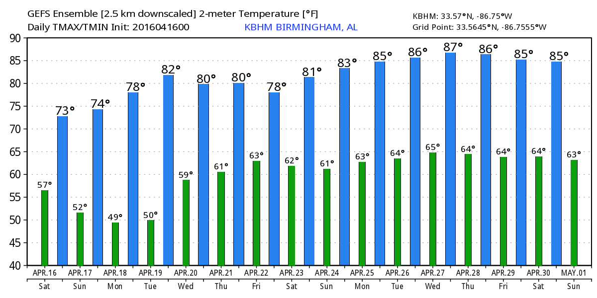
The pesky easterly flow along with a sort of wedge pattern continued this morning with much of the Southeast US cloudy and radar showing some patchy light rain showers stretching from Montgomery to western Jefferson County. Looks like the clouds and the possibility of some sprinkles or light rain will continue with us for the morning with some drying during the afternoon. We will probably see a little more sun peeking through the clouds during the mid to late afternoon. Highs today should reach the upper 60s and lower 70s.
The upper level weakness across the Southeast US and Lower Mississippi River Valley will continue to weaken tonight and Sunday, so I expect to see a much nicer day for us as sunshine returns on Sunday with highs climbing into the middle 70s, a value pretty typical for this time of year.
Just as we are seeing in Central Alabama, improving weather is expected for the northern Gulf Coast this weekend. It has been a rather dreary week for beach goers, but by later today, sunshine will return, and it will stick around through the middle of next week. Afternoon highs will be in the 70s, but water temperatures are still a little chilly. Yesterday afternoon at Perdido Pass at Orange Beach the water temperature was 69F. See the complete Gulf Coast 7 Day Planner here.
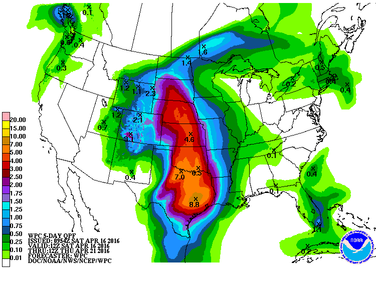
A combination of the upper ridge and surface high pressure is expected to keep us dry and warm through midweek. For now with a somewhat weak upper level pattern, I’m going to hold off any chance of rain until Thursday, but Wednesday will be a transition day as clouds increase with an increase in moisture as a surface high slides off into the Atlantic bringing the surface flow around to a southerly direction. A surface low, but one that is not forecast to be very strong, will move from eastern Kansas on Thursday to southern Michigan on Friday to off the New England coast by Saturday.
The movement of this surface system along with an upper level trough will drag a weak frontal boundary into the Southeast US Friday and Saturday. While temperatures will be warm with lows in the lower 60s and highs in the lower 80s, we are likely to see chances for showers from Thursday into the weekend.
The big event at Barber Motorsports Park is next weekend, April 22, 23, and 24. It is on the edge of voodoo country, so it’s difficult to be very specific. I also note that the past several long range model runs have been struggling with next week’s system. It still looks as though the pattern would support warm temperatures, with a chance of scattered showers next weekend. Still plenty of time to watch the forecast unfold. You will find ticket information here.
I’m putting this together a little bit earlier today due to an event down at UAB, the Mutt Strut. I will be at the ABC 3340 tent along with several other on-air people, so be sure to stop by our booth and say hello. The earlier production of this video together with slightly later model availability means that I do not have any of the GFS output into voodoo country.
The next Weather Xtreme Video will be posted here first thing on Sunday morning. I hope you have a great day and Godspeed.
-Brian-
Category: Alabama's Weather
About the Author (Author Profile)
Brian Peters is one of the television meteorologists at ABC3340 in Birmingham and a retired NWS Warning Coordination Meteorologist. He handles the weekend Weather Xtreme Videos and forecast discussion and is the Webmaster for the popular WeatherBrains podcast.Subscribe
If you enjoyed this article, subscribe to receive more just like it.


