

Scattered Shower/Storms Return
MOISTURE LEVELS RISING: The upper low/trough that has been over the western U.S., part of the “omega block” pattern earlier this week, is beginning to lift northeast, and accordingly showers should return to Alabama today and tonight.
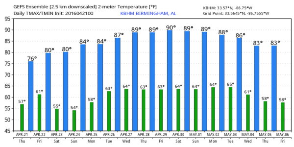
The rain won’t be too widespread or heavy, but a few thunderstorms could be involved. Rain amounts will be less than 1/2 inch for most, and no severe weather is expected. Temperatures reach the 77-80 degree range this afternoon with a generally cloudy sky (although the sun could peek out at times).
TOMORROW: While showers and storms remain possible, it looks like they will be pretty scattered in nature, and a decent part of the day will be dry. But, where storms do form tomorrow afternoon, they could be strong. SPC maintains a “marginal” severe weather risk for areas south of a line from Demopolis to Hoover to Anniston…
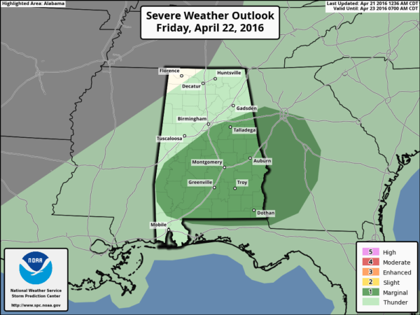
The main threat will come from small hail and gusty winds in the storms tomorrow afternoon over the southern two-thirds of the state. Expect a high temperature between 77 and 80 degrees, and showers will end from northwest to southeast during the afternoon as drier air arrives.
THE WEEKEND: Could not be better. Sunny warm days, clear at night. Saturday’s high will be close to 80, followed by low 80s Sunday.
NEXT WEEK: Warm is the word; highs will be in the 80s all week as ridging develops across the Southeast U.S. We will probably have a day or two with scattered showers, but the big action will be well to the west, where there will be multiple days with severe weather threats in a broad zone from Texas to Missouri and Iowa; SPC has risks defined now for days 6 through 8 (Tuesday through Thursday). See the Weather Xtreme video for maps, graphics, and more details.
AT THE BEACH: A few scattered showers and storms are possible through tomorrow with some sun breaking through at times, Then, expect mostly sunny days and fair nights Saturday through early next week. Highs from Panama City Beach over to Gulf Shores will be mostly in the 70s… See a very detailed Gulf Coast forecast here.
HONDA INDY GRAND PRIX OF ALABAMA: A few widely scattered showers or storms are possible at the Barber Motorsports Park tomorrow, but a decent part of the day will be dry and I think they get some racing in. Then, perfect weather Saturday and Sunday with sunny warm days. Highs for the weekend will be at or just over 80 degrees. Get ticket information here.
WEATHER BRAINS: Don’t forget you can listen to our weekly 90 minute netcast anytime on the web, or on iTunes. This is the show all about weather featuring many familiar voices, including our meteorologists here at ABC 33/40.
CONNECT: You can find me on all of the major social networks…
Facebook
Twitter
Google Plus
Instagram
I have a weather program this morning at Hueytown Elementary… look for the next Weather Xtreme video here by 4:00 this afternoon… enjoy the day!
Category: Alabama's Weather
About the Author (Author Profile)
James Spann is one of the most recognized and trusted television meteorologists in the industry. He holds the AMS CCM designation and television seals from the AMS and NWA. He is a past winner of the Broadcast Meteorologist of the Year from both professional organizations.Subscribe
If you enjoyed this article, subscribe to receive more just like it.


