

Very Nice Spring Weekend
I am handling weather support for the Honda Indy Grand Prix at Barber Motorsports, so there will not be a video this morning. There will probably not be a video tomorrow either.
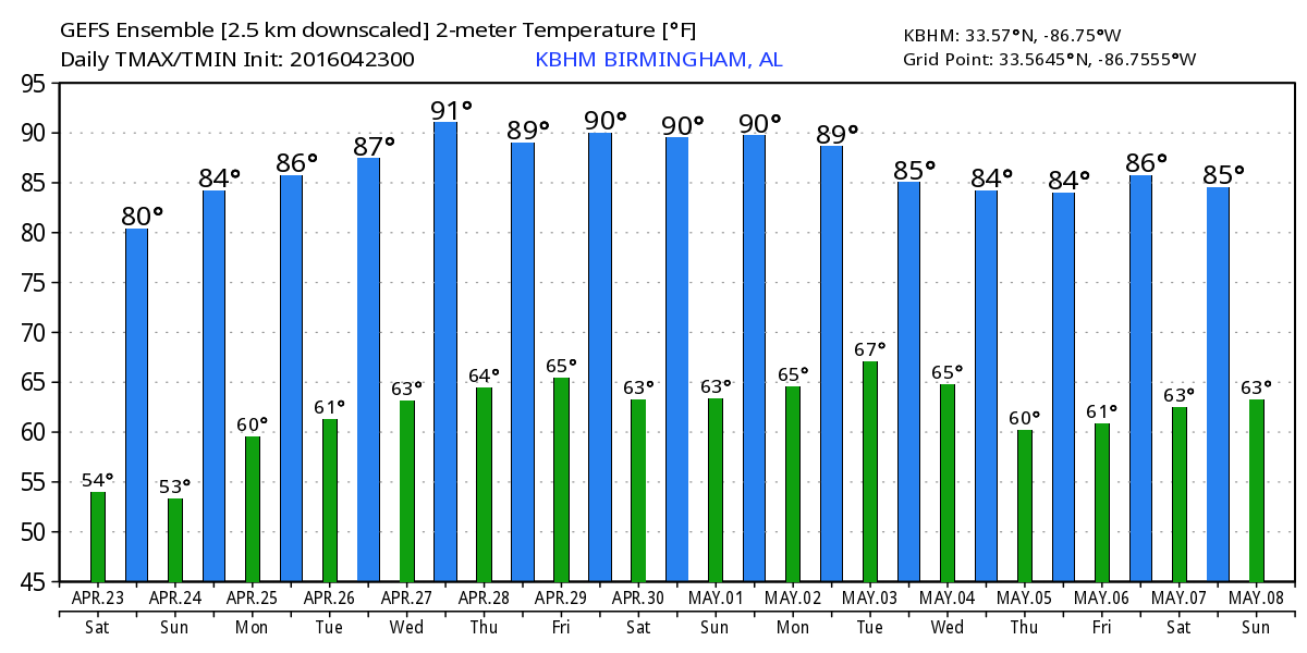
The weather looks great for the weekend with plenty of sunshine, highs in the upper 70s today and around 80 Sunday, and lower humidity so it will feel great, too. We started the day out on a cool-isa note with much of Central Alabama dipping back into the lower 50s with a few places across North Alabama in the middle and upper 40s.
For beach goers, look for mostly sunny days and fair nights on the Gulf Coast through the middle of the week with highs in the 70s on the immediate coast and 80s inland with morning lows mainly in the 60s. Sea water temperatures are mostly in the low 70s. See a very detailed Gulf Coast forecast here.
The Honda Indy Grand Prix of Alabama is being held at Barber Motorsports Park today and Sunday with sunny weather both days; 78 is the forecast high today with low 80s Sunday. Get ticket information here.

Talladega race weekend will be next weekend. While still a little early for a very specific forecast, the pattern is looking pretty good with warm and dry weather expected.
The upper trough that brought some unsettled weather to Central Alabama yesterday is moving off the Mid-Atlantic States today as we come under a strong ridge. The upper ridge along with a surface high will keep our weather warm and dry through the middle of the week. Look for highs to rise into the lower 80s through midweek with lows in the 60s.
For the latter half of next week, there seems to be fairly good agreement between the European and the GFS with a surface low moving across the southern portion of the Great Lakes and into the Atlantic. The ridge manages to hold fairly strong for the Southeast US as the surface low drags a weakening front into the area. This brings the potential for showers during the latter part of next week and potentially into the weekend.
The system at midweek looks strong so the SPC folks have included a risk of severe storms into Day 4 and Day 5. All indications are that this could be a fairly significant severe weather episode over a couple of days.
Looking out into voodoo country, the pattern remains active with a pretty stout trough around May 3rd that could spell some cooler weather for the eastern half of the county. Another low latitude trough enters the picture around May 6th that could spell some wet weather for the Central Gulf Coast area and the Southeast US. A deep closed low follows that on May 8th that has the potential for producing another round of severe storms.
And if you have been following the tropics at all, Fantala continued to church in the South Indian Ocean north of Madagascar but much weaker that it was a week ago. After going back and forth several times, the latest forecast track takes it into the eastern coast of Africa in a weakening condition around the 28th of April.
I will plan on posting another weather discussion tomorrow morning around 8 am or so. The conditions for producing a video are just not very conducive with people coming and going and the roar of race cars.
-Brian-
Category: Alabama's Weather
About the Author (Author Profile)
Brian Peters is one of the television meteorologists at ABC3340 in Birmingham and a retired NWS Warning Coordination Meteorologist. He handles the weekend Weather Xtreme Videos and forecast discussion and is the Webmaster for the popular WeatherBrains podcast.Subscribe
If you enjoyed this article, subscribe to receive more just like it.


