

A Few Storms Late Today And Tonight
QUIET MORNING: Temperatures are mostly in the 60s across North/Central Alabama early this morning, and the radar is quiet.
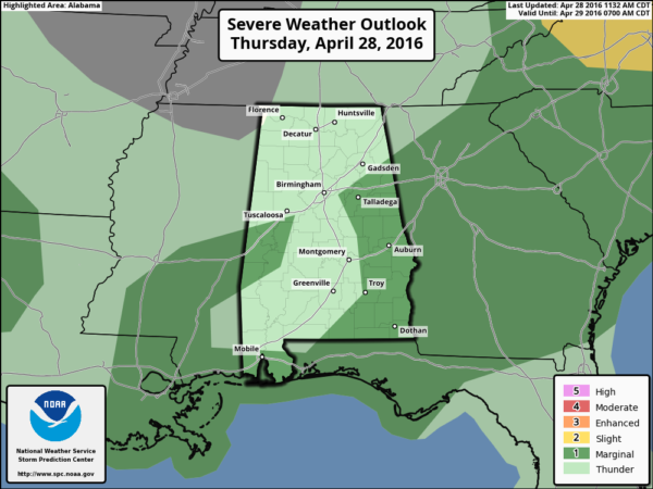
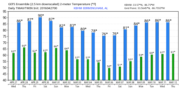
We rise into the 80s again today with a partly sunny sky. We will mention the risk of a shower or storm this afternoon or tonight, but the short range mesoscale models are really struggling with this pattern. The HRRR model brings in an organized batch of storms this afternoon, while the 4km NAM keeps it mostly dry. I get the idea most of today will be dry, but we will certainly mention that chance of a shower or thunderstorm this afternoon and tonight. SPC has defined a “slight risk” of severe storms for the far northwest corner of the state, with a “marginal risk” elsewhere; this outlook runs through 7:00 a.m. tomorrow…
Stronger storms could produce some small hail and gusty winds, but the overall severe weather threat is low through tonight.
TOMORROW: We will need to maintain some risk of showers/storms through tomorrow, but drier air begins to flow into North Alabama during the morning, and by afternoon the best coverage of rain will shift down into the southern half of the state. Instability values rise to very high levels tomorrow afternoon ahead of the surface front (CAPE values to 4,000 j/kg), but dynamic support will weaken during the day.
SPC has a “marginal risk” of severe storms defined for most of Central and South Alabama; again small hail and gusty winds are the main issues.
FRIDAY: The day will be warm and dry with a good supply of sunshine; we rise into the mid to upper 80s by afternoon. It will be one of the warmest days so far this year.
THE ALABAMA WEEKEND: Another storm system west of the state will organize, and moisture moves northward Saturday with some risk of showers. But, a decent part of the day should be dry, and temperatures once again will rise into the 80s by afternoon.
Showers and storms become more numerous Sunday as the weather system to the west gets closer. It won’t rain all day, but no doubt it will be wet at times. A strong storm is possible, but the overall severe weather threat looks rather low, and rain amounts should be in the 1/2 to 3/4″ range for most places. The high Sunday will be close to 80 degrees.
NEXT WEEK: Just a few lingering showers Monday, but the weather trends drier and cooler. Tuesday looks bright and sunny with lower humidity and a high in the 70s. A chance we see early morning lows down in the 40s later in the week… see the Weather Xtreme video for maps, graphics, and more details.
RACE WEEKEND AT TALLADEGA: Not much change in our thinking. Friday will be a beautiful day with a sunny sky, and afternoon temperatures well up into the 80s. Then, on Saturday, a passing shower or storm is certainly possible at the Superspeedway, but it won’t rain all day and they should get the Sparks Energy 300 in. The high Saturday afternoon will be in the mid 80s.
The weather Sunday will be more problematic as showers and storms become more widespread. Still, it won’t rain all day, and there is a chance the GEICO 500 will run, but just be ready for delays. Sunday’s high at the Superspeedway will be close to 80 degrees.
AT THE BEACH: About 5 to 7 hours of sunshine on the coast from Gulf Shores over to Panama City Beach each day through Friday with the risk of a few scattered showers or storms. Saturday will be partly to mostly sunny, then scattered storms are possible Sunday. Highs in the 70s along the immediate coast, with 80s inland. See a very detailed Gulf Coast forecast here.
APRIL 27 2011 SPECIAL: You can watch our one hour special here. It was on this date five years ago that 62 tornadoes killed 252 people in our state during a generational tornado outbreak.
WEATHER BRAINS: Don’t forget you can listen to our weekly 90 minute netcast anytime on the web, or on iTunes. This is the show all about weather featuring many familiar voices, including our meteorologists here at ABC 33/40.
CONNECT: You can find me on all of the major social networks…
Facebook
Twitter
Google Plus
Instagram
I will be doing a safety program today at ALAGASCO in Anniston… look for the next Weather Xtreme video here by 4:00 this afternoon. Enjoy the day!
Category: Alabama's Weather
About the Author (Author Profile)
James Spann is one of the most recognized and trusted television meteorologists in the industry. He holds the AMS CCM designation and television seals from the AMS and NWA. He is a past winner of the Broadcast Meteorologist of the Year from both professional organizations.Subscribe
If you enjoyed this article, subscribe to receive more just like it.


