

Wet, Wild, and Changing!
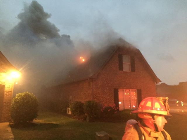
It looks like the next week or so is going to see some wet, wild, and changing weather for us in Central Alabama. It was wild yesterday afternoon and evening as a mesoscale convective system (MCS) rolled through Central Alabama producing a number of hail and wind damage reports along with numerous lightning strikes knocking out power and causing several house fires. The picture below is just one example of such a fire provided to us by the Alabaster Fire Department.
And the present pattern appears likely to stay unsettled for the next several days and that unsettled weather will be followed by a remarkably big change in the overall pattern.
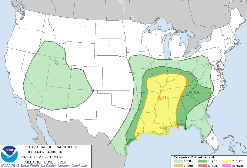
This morning we’re covered with a lot of clouds with the primary weather system located at the surface over the Central Plains of the US. The upper air pattern features a large closed low just east of Denver. That low will move eastward today with more thunderstorms forecast for Central Alabama. The Storm Prediction Center (SPC) has the western half of Alabama in the standard slight risk for severe weather today with damaging wind the biggest threat but isolated tornadoes will also be possible.
For the racing this weekend at Talladega, expect a mix of sun and clouds both days with the risk of a passing shower or storm from time to time. Unfortunately with showers and storm, we aren’t able to give specific times when one will pass through, but we don’t expect a big rain mass to set in for hours. A very good chance they get the Sparks Energy 300 in today, and the GEICO 500 in tomorrow, but a delay is possible either day. Keep an eye on radar. Please remember the 8 mile lightning rule. Lightning within 8 miles, you should get inside a substantial building or inside your car or truck. Don’t mess around with it! Lightning kills – don’t be a statistic.
If your plans call for heading to the beach, scattered showers and storms are possible for the next several days. Highs will be around 80 on the immediate coast with 80s inland. Low temperatures will be around 70. You will find a very detailed Gulf Coast forecast here.
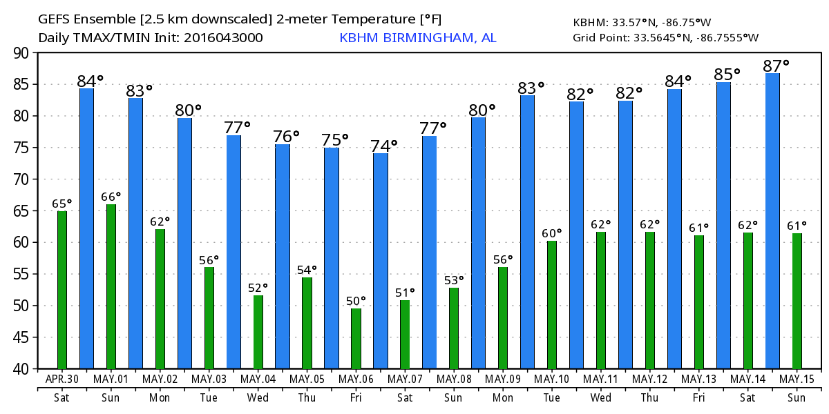
As the upper closed low works eastward in the flow it will weaken substantially, but it will also leave behind a trough over the Southwest US. At the surface, the surface low works across the Ohio River Valley with a front slowly dragging down into the Southeast US. By Monday and Tuesday, the upper trough over the Southwest US comes out across the Plains States and we begin to see a major change in the overall upper air pattern. We stay fairly warm with highs in the 80s but continued potential for showers and storms.
By Tuesday and Wednesday, a big ridge develops over the western US while a substantial trough develops over the eastern US. This will sweep the unsettled weather out of the area Tuesday with Wednesday becoming sunny and dry once again. Temperatures will gradually come down. By Thursday and Friday, the upper trough is forecast to really dig south with a pattern that will be more representative of one we see in the winter. Friday morning appears to be the chilliest according to the latest model data and we could well see morning lows well down into the 40s. This values could be 10 degrees colder than we typically see for early May.
The weather stays nice into the weekend as the upper ridge gradually weakens somewhat and moves eastward. Saturday we could still see some morning lows into the 40s with most places around 50 with the afternoon high in the mid 70s, the potential for a gorgeous early May weekend.
Looking further out into voodoo country, the pattern definitely stays active. The ridge keeps our weather good through May 9th. A strong trough comes across the Mississippi River around the 10th that promises some wet weather for the Southeast US. Another trough takes shape over the eastern US around the 12th of May and then the pattern begins to flatten somewhat around the 14th of May.
Looking forward to being out with other ABC 3340 staff members at Celebrate Hoover today. Be sure to come out to Veterans Park off Valleydale Road in Hoover and say hello. Lots of activities and things to see plus some great food choices. The event is free. I expect to have the next Weather Xtreme Video posted here by 8 am or so on Sunday morning.
-Brian-
Category: Alabama's Weather
About the Author (Author Profile)
Brian Peters is one of the television meteorologists at ABC3340 in Birmingham and a retired NWS Warning Coordination Meteorologist. He handles the weekend Weather Xtreme Videos and forecast discussion and is the Webmaster for the popular WeatherBrains podcast.Subscribe
If you enjoyed this article, subscribe to receive more just like it.


