

An Afternoon Update on the Alabama Weather Situation
It has been a muggy and warm spring afternoon across North and Central Alabama. Skies have been partly to mostly cloudy, with the most sunshine over East Central Alabama,
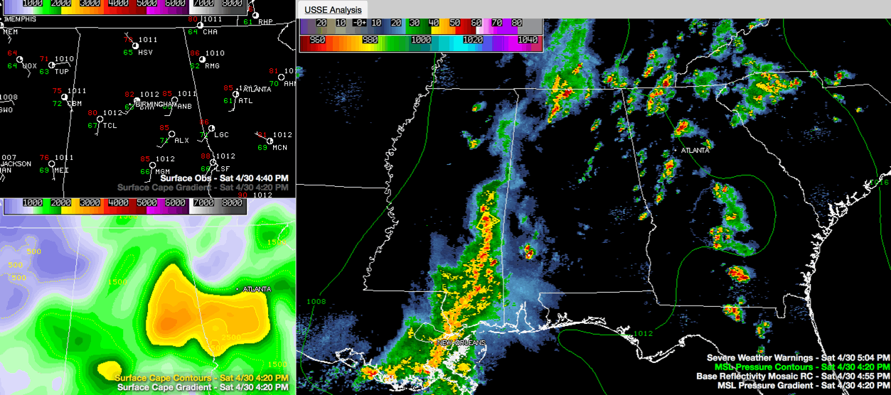
The airmass is slightly to moderately unstable with CAPE values running some 1,000-2,000 joules/kg, except over East Central Alabama, where values are over 2,000 joules. There are some values over 3,000 joules in places like Talladega, Wedowee, Alex City and Rockford.
So the atmosphere is primed for storms and they have formed over North Alabama, down through East Central Alabama into much of Georgia. Some are starting to percolate in northeastern Mississippi as well.
There actually was a tornado warning for Limestone and Madison counties in North Alabama into Lincoln County, Tennessee, but the warning has been canceled. The tornadic thunderstorm has moved from near Athens to Elkmont and will soon exit the state. It still has a severe thunderstorm warning on it. That storm has showed signs of rotation but no reports of tornadoes or damage so far.
The atmosphere is not really conducive for tornadoes across Alabama, with low 0-1 km helicity values. But with spring storms in Alabama we always say to expect the unexpected.
To the southwest, there is a big MCS (mesoscale convective system) moving into southwestern Alabama from southeastern Mississippi and southeastern Louisiana. The storms have been severe in the New Orleans area. There is currently a severe thunderstorm warning for Kemper County in eastern Mississippi, where Meridian is located. This storm will eventually affect Sumter County.
The whole MCS will lift northeastward into West Central Alabama, reaching Tuscaloosa between 6-7 p.m. and Birmingham by 7-8 p.m. But it will be weakening as it goes, leaving the better shear over Mississippi. The SPC has West Central and Southwest Alabama outlooked for a slight risk of severe weather, meaning scattered severe storms possible. The severe weather will be short lived and not widespread. Further east, most of the rest of the state is in a marginal risk outlook, meaning isolated severe storms are possible. There could be a few reports of damaging winds and hail, with the best chance over areas from Pickens down through Sumter and Hale Counties.
There is a severe thunderstorm watch in effect for coastal Mississippi and SE Louisiana. A new watch could be issued into Coastal Alabama and Northwest Florida.
We are sort of locked into this pattern through Monday it seems, when a cold front will finally push through the area, ending the rain. But expect more showers and storms Sunday and Monday. It looks like most of tomorrow’ rain may come in the morning for Central Alabama, hopefully leaving room for a decent afternoon.
Category: Alabama's Weather, Severe Weather
About the Author (Author Profile)
Bill Murray is the President of The Weather Factory. He is the site's official weather historian and a weekend forecaster. He also anchors the site's severe weather coverage. Bill Murray is the proud holder of National Weather Association Digital Seal #0001 @wxhistorianSubscribe
If you enjoyed this article, subscribe to receive more just like it.


