

Wet Weather Continues
AT DAYBREAK: All is calm across the great state of Alabama early this morning; the sky is mostly cloudy, but we have no rain on radar.
A surface front remains west of the state, and a wave of low pressure should move along that front today, and will bring widespread rain back to the state this afternoon and tonight. A few thunderstorms could be involved; SPC has defined a “marginal risk” of severe weather for about the northern third of Alabama…
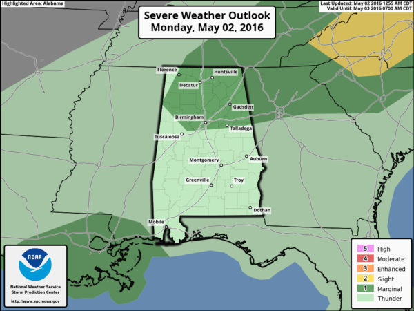
A few storms could produce hail and gusty winds, but the overall severe weather risk is pretty low due to marginal instability and weak dynamics. Additional rain amounts of around 1 inch are likely; we will need to watch for flooding issues since we saw a few pockets of 3-4″ rain amounts yesterday… some signifiant flooding was reported in places like Clanton and Oxford.
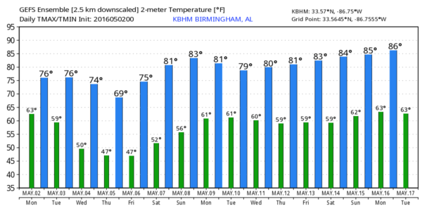
We won’t get out of the 70s today due to clouds and rain.
TOMORROW: Lingering showers will end early in the day, and the sky becomes partly sunny by afternoon as drier air works into North Alabama. Showers and storms will be confined to the southern half by then. The high tomorrow should be in the mid to upper 70s.
WEDNESDAY: The day should be mostly sunny and pleasant with a high in the 70s, but we will need to mention a chance of showers Wednesday night thanks a clipper approaching from the north. Rain won’t be too heavy; generally 1/4 inch or less for most places.
THURSDAY/FRIDAY: These two days will be cool and dry with sunny days and clear nights. Early morning lows will be in the 40s, and some of the traditionally colder spots across North/Central Alabama could reach the upper 30s early Friday morning (some people call it “Blackberry Winter”). The high Thursday will be around 70, with mid 70s Friday.
THE ALABAMA WEEKEND: Could not be better. Sunny warm days, clear cool nights. The high Saturday will be close to 80, followed by low 80s Sunday.
NEXT WEEK: Looks like the next chance of showers and storms will come around Tuesday or Wednesday of next week… see the Weather Xtreme video for maps, graphics, and more details.
AT THE BEACH: Showers and storms are likely on the coast from Gulf Shores over to Panama City Beach late today, tonight, and tomorrow, but expect dry, sunny weather Wednesday through the weekend. Highs will be in the 70s along the immediate coast, with upper 70s and low 80s inland. The sea water temperature early this morning at the Dauphin Island Sea Lab is 76 degrees. See a very detailed Gulf Coast forecast here.
WEATHER BRAINS: Don’t forget you can listen to our weekly 90 minute netcast anytime on the web, or on iTunes. This is the show all about weather featuring many familiar voices, including our meteorologists here at ABC 33/40. We will produce this week’s show tonight at 8:30 CT… you can watch it live here.
CONNECT: You can find me on all of the major social networks…
Facebook
Twitter
Google Plus
Instagram
I am speaking this morning at Central Elementary School in Tuscaloosa… look for the next Weather Xtreme video here by 4:00 this afternoon. Enjoy the day!
Category: Alabama's Weather
About the Author (Author Profile)
James Spann is one of the most recognized and trusted television meteorologists in the industry. He holds the AMS CCM designation and television seals from the AMS and NWA. He is a past winner of the Broadcast Meteorologist of the Year from both professional organizations.Subscribe
If you enjoyed this article, subscribe to receive more just like it.


