

Showers/Storms Increasing Across Alabama
RADAR CHECK: As expected, we have scattered to numerous showers and thunderstorms across Alabama this afternoon…
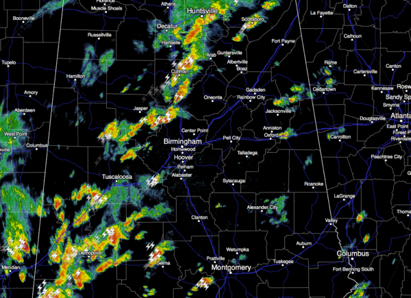
SPC maintains a “marginal risk” of severe weather for pretty much all of the state tonight; heavier storms will be capable of producing small hail and gusty winds, but a big severe weather problem is not expected. Some communities will also see heavy rain with potential for temporary flooding issues, but I doubt if we see 3 and 4 inch amounts like yesterday in cities like Clanton and Oxford.
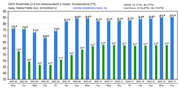
TOMORROW: Drier air works into the state, and it looks like best chance of showers and storms will be over South Alabama. For north/central counties, we will forecast a partly sunny sky with a high in the mid 70s.
WEDNESDAY: The morning will be mostly sunny with a high in the 70s, but a clipper moving in from the north will bring clouds during the afternoon, and the risk of showers Wednesday evening. Looks like the best chance of showers will come from 5:00 until 10:00 p.m., and rain amounts should be under 1/4 inch for most places.
THURSDAY/FRIDAY: Sunny pleasant days, clear cool nights with dry air in place. We drop down into the mid 40s early Friday morning; some of the traditionally colder spots might even reach the upper 30s at daybreak Friday. Not many mornings like that left before the long, hot summer gets here.
THE ALABAMA WEEKEND: Dry weather continues; lots of sun Saturday and Sunday with warming trend. We reach the low 80s Saturday, and mid 80s Sunday.
NEXT WEEK: We stay dry Monday… looks like the best chance of showers and storms will come around Wednesday. And, for now the severe weather threat looks low. See the Weather Xtreme video for maps, graphics, and more details.
AT THE BEACH: Showers and storms are likely on the coast from Gulf Shores over to Panama City Beach tonight and tomorrow, but expect dry, sunny weather Wednesday through the weekend. Highs will be in the 70s along the immediate coast, with upper 70s and low 80s inland. See a very detailed Gulf Coast forecast here.
WEATHER BRAINS: Don’t forget you can listen to our weekly 90 minute netcast anytime on the web, or on iTunes. This is the show all about weather featuring many familiar voices, including our meteorologists here at ABC 33/40. We will produce this week’s show tonight at 8:30 CT… you can watch it live here.
CONNECT: You can find me on all of the major social networks…
Facebook
Twitter
Google Plus
Instagram
I had a great time today visiting with the kids at Central Elementary in Tuscaloosa… be looking for them on the Pepsi KIDCAM today at 5:00 on ABC 33/40 News! The next Weather Xtreme video will be posted here by 7:00 a.m. tomorrow…
Category: Alabama's Weather
About the Author (Author Profile)
James Spann is one of the most recognized and trusted television meteorologists in the industry. He holds the AMS CCM designation and television seals from the AMS and NWA. He is a past winner of the Broadcast Meteorologist of the Year from both professional organizations.Subscribe
If you enjoyed this article, subscribe to receive more just like it.


