

Beautiful Day for Mother’s Day
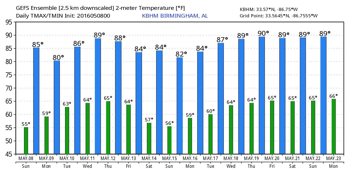
Happy Mother’s Day! Alabama was waking up about 5 to 7 degrees warmer this morning than yesterday morning with readings in the 50s. A clear sky this morning should see some afternoon clouds with lots of sunshine and those afternoon highs climbing into the middle 80s. Across the Central Plains from western Oklahoma northward through much of Central Kansas there is an enhanced risk of severe storms, so Mother’s Day will be somewhat stormy in the Nation’s breadbasket. Aloft, the big ridge has weakened somewhat, but it remained pretty strong as it gradually moves eastward with a ridge axis along the Mississippi River later today.
Gorgeous weather today and tomorrow along the beaches of Alabama and Northwest Florida. You can expect lots of sunshine along with afternoon highs mainly in the lower 80s. Scattered showers and storms return to the forecast for much of the week ahead, but much like here, no all day rains are expected with plenty of time to catch some sun. The sea water temperature at the Dauphin Island Sea Lab was 73 degrees. See the complete Gulf Coast 7 Day Planner here.
PROFESSIONAL GOLF BACK IN BIRMINGHAM: The Regions Traditions Golf Tournament returns to beautiful Greystone Golf and Country Club May 18-22. Way too early for a specific forecast just yet, but you’ll find the latest forecast for the event when it gets within range for reasonable forecasts. Click here for Regions Traditions Tickets.
The big trough over the Rockies will shed one piece of it Monday as a strong closed low moves nearly due north thanks to the blocking of the ridge over the eastern US. This will bring an round of severe storms to the area centered primarily on Arkansas but affecting parts of Missouri, Northeast Texas, and eastern Oklahoma. Monday is a transition day for the Southeast US as a strong southerly flow sets up increasing the moisture across our area. While we should see more clouds, I believe we’ll stay free of showers.
Showers and storms become an issue for us on Tuesday with the potential for scattered showers and storms to remain with us into late Thursday. While all of the upper air dynamics are taking place well to our north, warm afternoon temperatures and plenty of moisture will require mentioning daily chances of showers for Tuesday, Wednesday, and Thursday. It seems that our best rain chances are likely to come on Thursday with the approach of a cold front. Due to the scattered nature of the storms even with the approach of the cold front, rainfall is likely to remain relatively low with amounts of half inch or less.
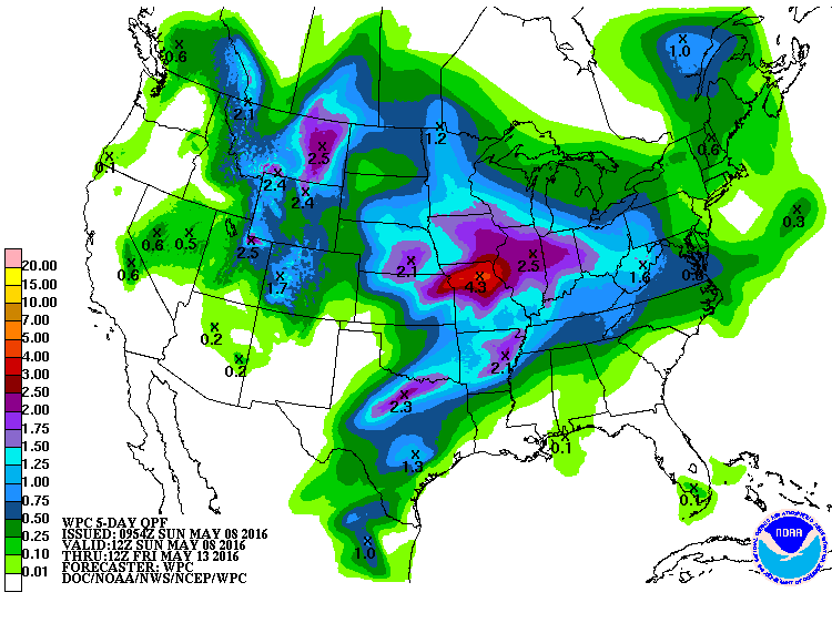
From Thursday into Friday, the upper air pattern becomes a trough over the eastern half of the country. This will help to force the fairly week front at the surface through the Southeast US Thursday or very early Friday morning. This should sweep the moisture out of the state as dew points drop back from the lower and middle 60s into the 50s. There is enough instability that we will probably hear some thunder, but with the best dynamics well north of Central Alabama, we should not have to deal with any kind of serious severe weather threat.
With the trough established in the East, the upper air flow remains northwesterly for Alabama into the weekend while surface high pressure promises to bring good weather with lows mainly in the upper 50s and 60s and highs in the 80s.
Looking further afield, voodoo country was pretty tame yesterday, but as we see quite often, there is a big change for week 2 on the latest computer model run. The GFS keeps the eastern US trough in place through May 19th. From the 19th to the end of the period around May 23rd, we see the pattern evolve as the ridge moves east displacing the eastern US trough with the development of another strong trough and closed low in the Central Plains states. While it is 372 hours out, the pattern the GFS is projecting around the 23rd of May is certainly one that would be favorable for a fairly significant round of severe storms potentially from the Central Plains into the Lower Mississippi River Valley. Remember, we’re not making a specific forecast, but trying to establish trends based on what the patterns show.
James Spann will be back with the next edition of the Weather Xtreme Video first thing on Monday morning. Enjoy your Mother’s Day. Stay cool and Godspeed.
-Brian-
Category: Alabama's Weather
About the Author (Author Profile)
Brian Peters is one of the television meteorologists at ABC3340 in Birmingham and a retired NWS Warning Coordination Meteorologist. He handles the weekend Weather Xtreme Videos and forecast discussion and is the Webmaster for the popular WeatherBrains podcast.Subscribe
If you enjoyed this article, subscribe to receive more just like it.


