

Significant Weather Advisory – Southeastern Cherokee, Cleburne, & Eastern Calhoun Counties Until 9:30 PM CDT
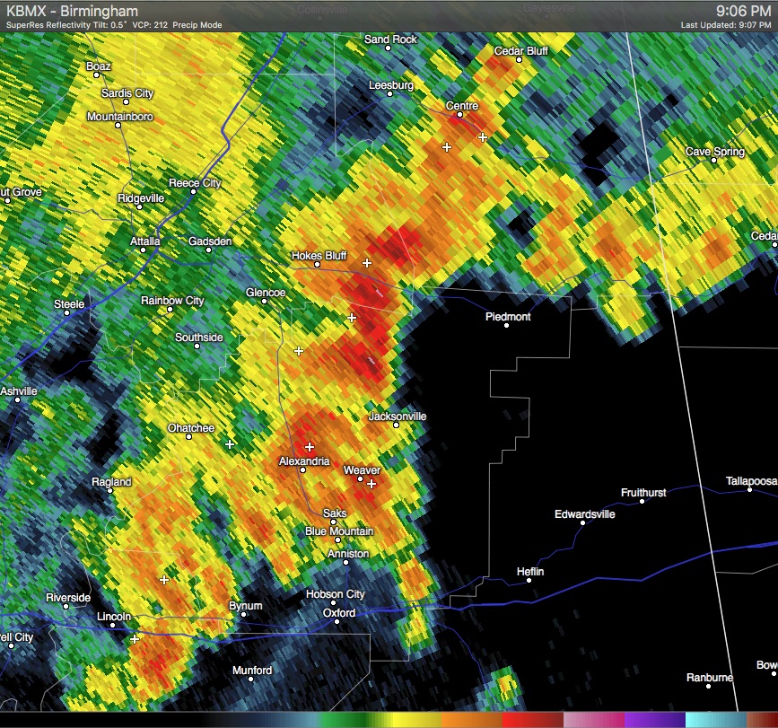
A Significant Weather Advisory has been issued for Southeastern Cherokee, Cleburne, & Eastern Calhoun Counties until 9:30 PM CDT. A line of strong thunderstorms were located near Ball Flat and Fort McClellan, and was moving east at 45 MPH. Gusty winds of 40 MPH or greater could be possible with this storm. Locations in the path of this storm are listed below. Please seek shelter immediately.
…SIGNIFICANT WEATHER ADVISORY FOR SOUTHEASTERN CHEROKEE…CLEBURNE
AND EASTERN CALHOUN COUNTIES UNTIL 930 PM CDT…
AT 904 PM CDT…DOPPLER RADAR WAS TRACKING STRONG THUNDERSTORMS ALONG
A LINE EXTENDING FROM NEAR BALL FLAT TO FORT MCCLELLAN. MOVEMENT WAS
EAST AT 45 MPH.
WINDS IN EXCESS OF 40 MPH WILL BE POSSIBLE WITH THESE STORMS.
LOCATIONS IMPACTED INCLUDE…
ANNISTON…OXFORD…JACKSONVILLE…PIEDMONT…CENTRE…HEFLIN…COBB TOWN…
FORT MCCLELLAN…FORNEY…WEST END-COBB TOWN…SAKS…WEAVER…FRUITHURST…
EDWARDSVILLE…BALL FLAT…TENNALA…MARS HILLS…BLUE MOUNTAIN…
MUSCADINE AND PLEASANT GAP.
Category: Alabama's Weather, Severe Weather
About the Author (Author Profile)
Scott Martin is an operational meteorologist, professional graphic artist, musician, husband, and father. Not only is Scott a member of the National Weather Association, but he is also the Central Alabama Chapter of the NWA president. Scott is also the co-founder of Racecast Weather, which provides forecasts for many racing series across the USA. He also supplies forecasts for the BassMaster Elite Series events including the BassMaster Classic.Subscribe
If you enjoyed this article, subscribe to receive more just like it.


