

Wet At Times Today; A Dry Weekend
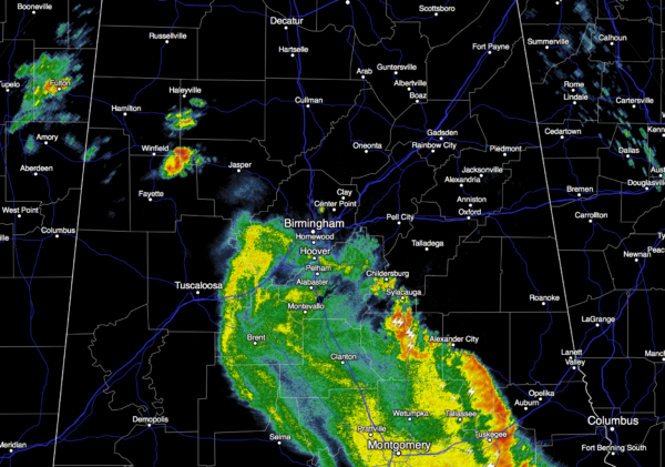
RADAR CHECK: A large MCS (mesoscale convective system) has been moving across the southern half of the state during the pre-dawn hours, and new showers and storms are forming over North Alabama at daybreak.
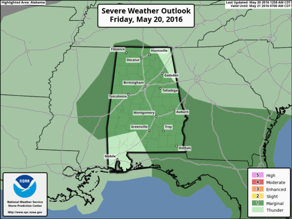
Our friends at the Storm Prediction Center have much of the state in a “marginal risk” of severe weather…
The good news is that the early morning storm mass over South Alabama has disrupted wind fields across Alabama, and that should lessen the risk of severe storms this afternoon. And, it should also mean lowered rain amounts since the inflow from the Gulf has been cut off for a while. Still, heavier storms later today could produce small hail and gusty winds as they pass through during the peak of the daytime heating process.
Showers and storms today will be more scattered than earlier thought, but still most communities should see around 1/2 inch of rain, with isolated amounts to one inch where heavier storms develop. Showers and storms will taper off early tonight as drier air begins to work into the state.
THE WEEKEND: We could see some lingering clouds early tomorrow morning, otherwise we expect mostly sunny, warm weather tomorrow and Sunday with high temperatures close to, or just over 80 degrees. Humidity levels will be a bit lower, and we should drop into the 50s early Sunday morning.
NEXT WEEK: Warm, dry weather continues Monday and Tuesday… then we will mention just the risk of widely scattered afternoon showers Wednesday through Friday; nothing to suggest anything really heavy widespread. Highs will be in the 80s… see the Weather Xtreme video for maps, graphics, and more details.
AT THE BEACH: The Hangout Music Festival is this weekend at Gulf Shores… they had some big storms early this morning, and a few additional showers and storms are possible later today and early tonight. But, it won’t rain all day, and the sun will break out at times. Then, the sky will be mostly sunny tomorrow and Sunday. Highs will be close to 80 on the immediate coast; the sea water temperature early this morning at the Dauphin Island Sea Lab is 79 degrees. See a very detailed Gulf Coast forecast here.
REGIONS TRADITION: Despite occasional showers and storms today, they should be able to get some golf in at Greystone. Better chance of a stronger storm comes this afternoon, and the high will be in the 77-80 degree range. The weather will be fine tomorrow and Sunday with ample sunshine and highs close to 80 degrees. Get more information about the tournament here.
SEC BASEBALL TOURNAMENT: Coming up at the Hoover Met May 24-29… for now the weather looks warm and dry Tuesday, then we will mention warm, humid conditions Wednesday through the weekend (May 25-29) with only widely scattered afternoon showers or thunderstorms. Highs will be in the 80s. Get information about the big event here.
WEATHER BRAINS: Don’t forget you can listen to our weekly 90 minute netcast anytime on the web, or on iTunes. This is the show all about weather featuring many familiar voices, including our meteorologists here at ABC 33/40.
CONNECT: You can find me on all of the major social networks…
Facebook
Twitter
Google Plus
Instagram
I have a weather program this morning at Hamilton Elementary School in Marion County… look for the next Weather Xtreme video here by 4:00 this afternoon. Enjoy the day!
Category: Alabama's Weather
About the Author (Author Profile)
James Spann is one of the most recognized and trusted television meteorologists in the industry. He holds the AMS CCM designation and television seals from the AMS and NWA. He is a past winner of the Broadcast Meteorologist of the Year from both professional organizations.Subscribe
If you enjoyed this article, subscribe to receive more just like it.


