

Monday Midday Nowcast for Central Alabama
After a nice cool morning today in Central Alabama, a great day is in store. Temperatures started off in the low 50s for most spots in the area, but a few upper 40s were reported. Its probably going to be a while, maybe late September, before we will see temperatures this low again. Get ready, as summer is quickly approaching, and we’ll get an early taste of it this week as temperatures will be above normal for this time of year.
QUICK LOOK AT TEMPERATURES: Most communities are into the upper 70s and low 80s, with the warm spot in the state being Huntsville at 82. Here is a list of temperature readings from across the state at this time:
Birmingham 78
Tuscaloosa 80
Muscle Shoals 79
Huntsville 82
Anniston 78
Alexander City 77
Montgomery 81
Dothan 81
Mobile 80
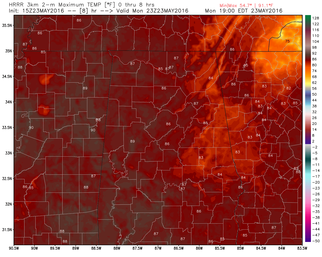
Latest Model Run With Today’s Maximum Temperatures
REST OF TODAY: A beautiful and dry day is expected for the remainder of today. A few clouds may move across the area later this afternoon and evening. Lower dewpoint/humidity will make it feel pretty comfortable, and with a nice northwesterly wind averaging 5 to 10 MPH. Highs will reach the mid to upper 80s for most communities in Central Alabama.
CLIMATOLOGY FOR BIRMINGHAM: The normal high temperature for May 23rd in Birmingham is 83, while the normal low is 60. The record high of 95 was reached in 1996. The record low of 47 was set back in 1954.
TUESDAY: Tomorrow will still feel fairly comfortable, as dewpoints and humidity levels will remain lower. Skies will be mostly sunny, and afternoon temperatures will reach the upper 80s. Early morning lows will be in the mid to upper 50s.
HEADED TO THE BEACH: Sunny days, clear nights through the Memorial Day weekend from Panama City Beach to Gulf Shores. Highs in the low 80s on the immediate coast; 87-90 degrees inland. Sea water temperature early this morning at the Dauphin Island Sea Lab is 78 degrees. See a very detailed beach forecast here.
SEC BASEBALL TOURNAMENT: It begins tomorrow at the Hoover Metropolitan Stadium; the weather looks fantastic with mostly sunny days and fair nights through at least Friday. We will mention a small risk of an afternoon shower or storm Saturday and Sunday, but rain should pose no big issues. The weather will heat up with highs in the 87-90 degree range most afternoons. Get information about the big event here.
WEATHERBRAINS: This week, we were talking rip currents with Jeff Medlen from the NWS in Mobile. Did you know that rip currents are typically the deadliest weather phenomenon in their County Warning Area? Learn more about the science behind rip currents on the weekly netcast that’s all about weather at www.WeatherBrains.com. You can also subscribe on iTunes. You can watch the show live at https://live.bigbrainsmedia.com/. You can also see the show on the James Spann 24×7 weather channel on cable or satellite or directly over the air on the dot 2 feed.
Category: Alabama's Weather
About the Author (Author Profile)
Scott Martin is an operational meteorologist, professional graphic artist, musician, husband, and father. Not only is Scott a member of the National Weather Association, but he is also the Central Alabama Chapter of the NWA president. Scott is also the co-founder of Racecast Weather, which provides forecasts for many racing series across the USA. He also supplies forecasts for the BassMaster Elite Series events including the BassMaster Classic.Subscribe
If you enjoyed this article, subscribe to receive more just like it.


