

The Memorial Day Midday Nowcast for Central Alabama

HAPPY MEMORIAL DAY: So far, it has been a beautiful and warm day across the Central Alabama area. Remember that Memorial Day is meant to be about honoring our hero warriors who gave their lives protecting the freedoms we hold so dear. Let’s take time to remember that today and the families left behind.
SATELLITE & RADAR CHECK: Currently across the area, it is mostly sunny with a few cumulus clouds dotting the skies. There is currently no rain showing on radar, and I believe that for most areas through the rest of today will stay hot and dry.
QUICK LOOK AT TEMPERATURES: Temperatures at this time are already well up in the upper 80s, with some 90s showing up in the southern part of the area. The warm spot in the state is Montgomery at 92. Here is a list of temperature readings from across the state at this time:
Birmingham 86
Tuscaloosa 89
Muscle Shoals 86
Huntsville 88
Anniston 87
Alexander City 88
Montgomery 92
Dothan 91
Mobile 89
REST OF TODAY: It will be hot out there today, but other than that, the weather looks great for any outdoor activities that you may have planned this afternoon and into the evening. Skies will remain mostly sunny, and afternoon highs will reach at or slightly above 90 degrees. There is a very slight chance of a shower, but the odds are so small that it’s really not worth mentioning.
AIR QUALITY ALERT FOR BIRMINGHAM AREA: Today’s Air Quality Index will be in the CODE YELLOW (moderate) for ozone and particulate matter. Unusually sensitive people should consider limiting prolonged outdoor exertion.
CLIMATOLOGY FOR BIRMINGHAM: The normal high temperature for May 27th in Birmingham is 84, while the normal low is 62. The record high of 97 was reached in 1914. The record low of 41 was set back in 1984.
TOMORROW: Pretty much a carbon copy of today. Partly to mostly sunny skies and hot during the day, and fair skies during the evening. Afternoon highs will be at or slightly over 90 degrees again. Little, if any, chance of rain.
HEADED TO THE BEACH: Mostly sunny days, fair nights on the coast from Gulf Shores over to Panama City Beach through Friday; a few widely scattered showers or storms will be possible over the weekend, but you will see see a good supply of sunshine both days. Highs in the low to mid 80s on the immediate coast, and closer to 90 inland. See a very detailed beach forecast here.
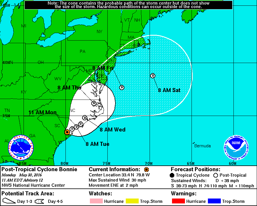
THE TROPICS: Weak, disorganized Post-Tropical Cyclone Bonnie is near Charleston, South Carolina, and will move northeast along the coast of the Carolinas in coming days with breezy, showery conditions continuing. The rest of the Atlantic basin is quiet.
WEATHERBRAINS: Don’t forget you can listen to our weekly 90 minute netcast anytime on the web, or on iTunes. This is the show all about weather featuring many familiar voices, including our meteorologists at ABC 33/40. You can find it here.
Category: Alabama's Weather
About the Author (Author Profile)
Scott Martin is an operational meteorologist, professional graphic artist, musician, husband, and father. Not only is Scott a member of the National Weather Association, but he is also the Central Alabama Chapter of the NWA president. Scott is also the co-founder of Racecast Weather, which provides forecasts for many racing series across the USA. He also supplies forecasts for the BassMaster Elite Series events including the BassMaster Classic.Subscribe
If you enjoyed this article, subscribe to receive more just like it.


