

Wet At Times This Weekend
RADAR CHECK: So far most of the showers and storms today across Alabama have come over the far northern counties, over the Tennessee Valley…
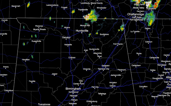
We will maintain the risk of a few scattered showers and storms tonight as the upper trough over Texas gets closer. Temperatures this afternoon are very close to 90 degrees in most spots.
THE WEEKEND: The upper trough will bring scattered to numerous showers and thunderstorms statewide tomorrow and Sunday. The rain won’t be continuous, but if you have something planned outdoors, just understand a shower or storm is possible at any time. The sky will be occasionally cloudy, and the high will drop into the mid 80s. Some places could hold in the 70s all day Sunday where showers form early in the day.
SPC maintains a “marginal risk” of severe storms Sunday for areas along and south of I-59…

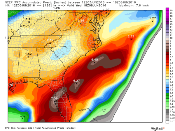
Some of the storms Sunday could produce small hail and gusty winds. Rain amounts over the weekend will average one inch, but some places will get more where heavier downpours develop.
NEXT WEEK: Dry air moves in Monday, and the northern half of the state will be dry with a good supply of sunshine and lower humidity levels. And, at this point it looks like the dry air will stay in place all the way through Friday with sunny days and clear nights continuing. We could see a few mornings with lows in the upper 50s. A rare chance to go five days in June without “scattered afternoon and evening thunderstorms”.
TROPICS: Bonnie has become a tropical storm again, east of the Outer Banks of North Carolina… but it will dissipate over the open Atlantic this weekend as it moves east.
A tropical low in the Gulf of Mexico could become a tropical depression Monday; it will move into the northern part of the Florida Peninsula (not the panhandle) late Monday night and early Tuesday, and the main issue will be heavy rain for places like Tampa, St. Petersburg, Jacksonville, Orlando, Fort Myers, and Daytona Beach.
If you have a trip planned to Disney World, this is just a one day rain issue the rest of the week will be mostly rain-free across Central Florida. And, the tropical low won’t directly impact Alabama or the Gulf Coast, but rip tides are possible Monday and Tuesday at places like Gulf Shores and Destin.
GULF COAST WEATHER: About 4 to 6 hours of sunshine tomorrow and Sunday along the Gulf Coast from Gulf Shores east to Panama City Beach with the chance of scattered showers and thunderstorms. Then, next week looks great with mostly sunny days and fair nights. Highs generally in the 80s. See a very detailed Gulf Coast forecast here.
WEATHER BRAINS: Don’t forget you can listen to our weekly 90 minute netcast anytime on the web, or on iTunes. This is the show all about weather featuring many familiar voices, including our meteorologists here at ABC 33/40.
CONNECT: You can find me on all of the major social networks…
Facebook
Twitter
Google Plus
Instagram
Look for my next Weather Xtreme video here Monday morning by 7:00 a.m…. Brian Peters will have the video updates tomorrow and Sunday. Enjoy the weekend!
Category: Alabama's Weather
About the Author (Author Profile)
James Spann is one of the most recognized and trusted television meteorologists in the industry. He holds the AMS CCM designation and television seals from the AMS and NWA. He is a past winner of the Broadcast Meteorologist of the Year from both professional organizations.Subscribe
If you enjoyed this article, subscribe to receive more just like it.


