

TD#3 Remains Disorganized
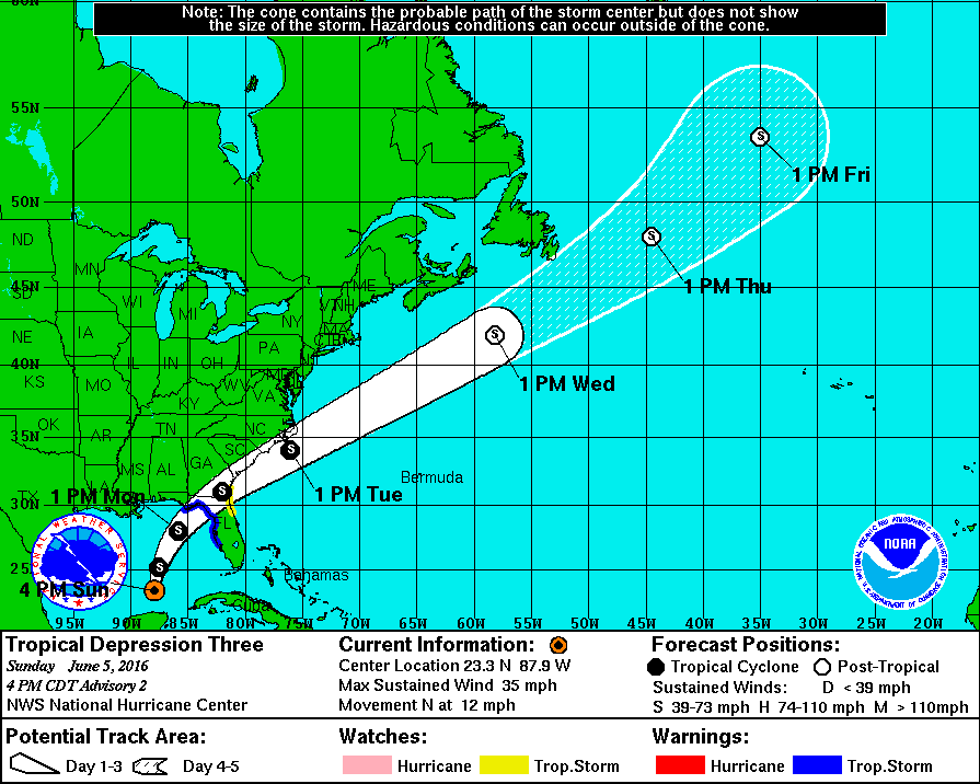
An Air Force Reserve WX-130 is flying a reconnaissance mission in Tropical Depression Number 3 over the southern Gulf of Mexico. They are not finding a very organized system at this time. It appears to have an elongated center north of the Yucatan Peninsula. The plane found maximum flight level winds of around 30-35 knots in its northwest semicircle. The plane is currently flying northward through the eastern semicircle. We will continue to monitor the reports from the crew.
The GFDL model organizes the storm slowly overnight before significant intensification occurs tomorrow afternoon as the center nears the coast of the Florida Big Bend. It projects a central pressure of 999 mb and top winds of about 60 mph at landfall near Cross City FL.
The HRWF is much weaker with the system.
The European brings it ashore near midnight tomorrow night just west of Cross City with a small area of tropical storm force winds from Tampa up to the Florida Big Bend area.
3-4 inches of rainfall will be common along with winds of 50 mph. Tornadoes will also be a threat.
The system will cross northern Florida and southeastern Georgia before emerging back over the Atlantic. It will intensify briefly again before becoming a post tropical storm.
ALABAMA UPDATE 4 PM
The cold front extends from near the Northwest Corner of Alabama southwestern across north Central Mississippi back to near Natchez this afternoon. Showers and thunderstorms continue across North and North Central Alabama at this hour. The strongest storms are in the Huntsville and Decatur area with others across parts of Marshall, Cullman back into northern Walker County. In Mississippi, strong storms are near I-55 north of Jackson.
Storms across Alabama will produce heavy rain, gusty winds and dangerous lightning into this evening. They should weaken after sunset, but here will remain a chance of showers through the overnight and into tomorrow morning.
Category: Tropical
About the Author (Author Profile)
Bill Murray is the President of The Weather Factory. He is the site's official weather historian and a weekend forecaster. He also anchors the site's severe weather coverage. Bill Murray is the proud holder of National Weather Association Digital Seal #0001 @wxhistorianSubscribe
If you enjoyed this article, subscribe to receive more just like it.


