

Long Dry Spell Ahead
RADAR CHECK: Widely scattered showers are over North/Central Alabama this afternoon, just south of a surface front near U.S. 278. A few neighborhoods did see a decent downpour this afternoon, but most communities are dry.
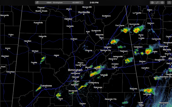
Once these showers dissipate this evening, it looks like a long dry spell ahead for Alabama.
Tomorrow will be dry with a good supply of sunshine; the afternoon high will be in the 87 to 90 degree range.
WEDNESDAY/THURSDAY: A drier airmass drops in from the north, and that will bring cooler nights. We should drop into the upper 50s both Wednesday and Thursday morning, not bad at all for June in Alabama. The high Wednesday will be in the mid 80s, followed by upper 80s Thursday.
HERE COMES THE HEAT: Get ready for the hottest weather so far this year by the weekend. Friday will be another sunny day with a high in the low 90s, then we project mid 90s Saturday and Sunday with sunny weather continuing. Some spots could even reach the upper 90s over the weekend. And, the upper high will keep it rain-free… a very good chance we go six days (tomorrow through Sunday) in a row with no afternoon showers, very unusual for summer.
NEXT WEEK: The upper ridge weakens a bit, and with a rise in low level moisture we should see the return of “scattered, mostly afternoon and evening showers and thunderstorms” early in the week with highs close to 90 degrees. See the Weather Xtreme video for maps, graphics, and more details.
TROPICAL STORM COLIN: The system is very asymmetrical this afternoon due to shear, and dry air is entering the western part of the circulation, so it won’t be getting any stronger. The center of circulation will move into North Florida, below Apalachee Bay tonight. The main issue will be heavy rain along with the threat of isolated tornadoes across North and Central Florida.
Colin will move off quickly to the northeast, and weather will improve greatly across Florida tomorrow.
GULF COAST WEATHER: Showers and storms will end tonight across the Florida Panhandle, and the weather looks great tomorrow through the weekend with mostly sunny days and fair nights from Gulf Shores over to Panama City Beach. Any showers will be few and far between, and highs will be in the 80s along the immediate coast. Inland communities will rise into the 90s by Friday and the weekend. See a very detailed Gulf Coast forecast here.
WEATHER BRAINS: Don’t forget you can listen to our weekly 90 minute netcast anytime on the web, or on iTunes. This is the show all about weather featuring many familiar voices, including our meteorologists here at ABC 33/40. We will produce this week’s show tonight at 8:30 CT… you can watch it live here.
CONNECT: You can find me on all of the major social networks…
Facebook
Twitter
Google Plus
Instagram
Look for the next Weather Xtreme video here by 7:00 a.m. tomorrow…
Category: Alabama's Weather
About the Author (Author Profile)
James Spann is one of the most recognized and trusted television meteorologists in the industry. He holds the AMS CCM designation and television seals from the AMS and NWA. He is a past winner of the Broadcast Meteorologist of the Year from both professional organizations.Subscribe
If you enjoyed this article, subscribe to receive more just like it.


