

Rising Heat/Humidity Levels
ANOTHER REFRESHING MORNING: Our Skywatcher at Black Creek (just northeast of Gadsden), Vic Bell, is reporting 50 degrees just before 6:00 this morning; many other North Alabama communities are in the 50s. That means dry, continental air remains in place, and today will be another sunny day with no risk of showers. But, temperatures begin to creep up this afternoon with a high around 90 degrees.
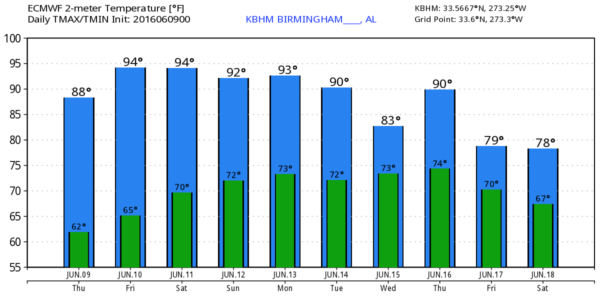
TOMORROW/SATURDAY: Expect rising heat and humidity levels. A good supply of sunshine both days, low 90s tomorrow, with potential for mid 90s in spots Saturday. With higher moisture levels, a few isolated showers could pop up Saturday afternoon during the heat of the day, but the risk of any one spot getting wet still looks very small.
SUNDAY/MONDAY: We will introduce the risk of “widely scattered, mostly afternoon and evening showers and thunderstorms” on these two days as the upper ridge weakens a bit. Still, expect partly sunny days with highs in the 92-95 degree range.
REST OF NEXT WEEK: Global models suggest now that showers and storms will become more numerous Tuesday on through the rest of the week as the ridge continues to weaken, instability values go higher, and moisture levels continue to rise. Looks like scattered to numerous showers and storms, mostly during the afternoon and evening hours, with highs 88-92. See the Weather Xtreme video for maps, graphics, and more details.
AT THE BEACH: Mostly sunny weather continues along the Gulf Coast today from Panama City Beach over to Gulf Shores. Then, for tomorrow, Saturday, and Sunday, about 7 to 9 hours of sunshine daily with the risk of a few scattered showers and thunderstorms (pretty typical setup for summer). Highs on the immediate coast will be in the 80s, with low to mid 90s inland. See a very detailed Gulf Coast forecast here.
TROPICS: NHC shows a weak disturbance near Key West with only a 10 percent chance of any development in coming days; the rest of the Atlantic basin is quiet.
AIR QUALITY ALERT: A code orange air quality alert has been issued for the Birmingham metro (Jefferson/Shelby Counties) today.
WEATHER BRAINS: Don’t forget you can listen to our weekly 90 minute netcast anytime on the web, or on iTunes. This is the show all about weather featuring many familiar voices, including our meteorologists here at ABC 33/40.
CONNECT: You can find me on all of the major social networks…
Facebook
Twitter
Google Plus
Instagram
Look for the next Weather Xtreme video here by 4:00 this afternoon… enjoy the day!
Category: Alabama's Weather
About the Author (Author Profile)
James Spann is one of the most recognized and trusted television meteorologists in the industry. He holds the AMS CCM designation and television seals from the AMS and NWA. He is a past winner of the Broadcast Meteorologist of the Year from both professional organizations.Subscribe
If you enjoyed this article, subscribe to receive more just like it.


