

Drier Air Arrives Over The Weekend
RADAR CHECK: As expected, showers and storms are less numerous across the northern half of Alabama today…
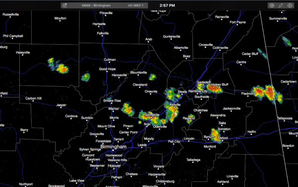
And, also as expected, heat levels are up with most places reporting low 90s at mid-afternoon. Dew points are well up in the 70s, making for a very streamy, uncomfortable afternoon. We will maintain the risk of widely scattered storms through about 10:00 tonight.
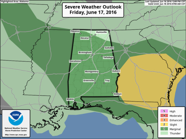
TOMORROW: Not much change. Hot, humid weather continues with a mix of sun and clouds and the risk of widely scattered, mostly afternoon and evening showers and storms. A surface front will approach, and SPC has much of the state in a “marginal risk” of severe storms tomorrow…
Stronger storms tomorrow afternoon will be capable of producing a wet microburst, but many places won’t see any rain at all due to the scattered nature of the convection. The high will be in the mid 90s for most communities.
THE ALABAMA WEEKEND: Heat and humidity levels come down with dry, continental air entering the state from the north. We expect mostly sunny days and fair pleasant nights with highs in the 80s and lows in the 60s. Cooler pockets have a good chance of reaching the 50s early Sunday morning.
NEXT WEEK: The weather stays dry Monday and Tuesday with a slow warming trend, then we will mention the risk of scattered showers and storms Wednesday through Friday. Highs will be generally in the 89-92 degree range through the week… see the Weather Xtreme video for maps, graphics, and more details.
TROPICS: Lower pressure over Central America is moving northwest, and could emerge into the far Southwest Gulf of Mexico in a few days, but elsewhere tropical storm development is not expected across the Atlantic basin through early next week.
AT THE BEACH: About 5 to 7 hours of sunshine tomorrow from Gulf Shores over to Panama City Beach with scattered showers and thunderstorms. Then, for the weekend, expect increasing amounts of sun with fewer showers as dry air works into the region from the north. Highs will be in the upper 80s on the immediate coast, with low 90s inland. See a very detailed Gulf Coast forecast here.
WEATHER BRAINS: Don’t forget you can listen to our weekly 90 minute netcast anytime on the web, or on iTunes. This is the show all about weather featuring many familiar voices, including our meteorologists here at ABC 33/40. We will produce a “Thursday night special” tonight at 8:30 CT… you can watch it live here.
CONNECT: You can find me on all of the major social networks…
Facebook
Twitter
Google Plus
Instagram
Look for the next Weather Xtreme video here by 7:00 a.m. tomorrow…
Category: Alabama's Weather
About the Author (Author Profile)
James Spann is one of the most recognized and trusted television meteorologists in the industry. He holds the AMS CCM designation and television seals from the AMS and NWA. He is a past winner of the Broadcast Meteorologist of the Year from both professional organizations.Subscribe
If you enjoyed this article, subscribe to receive more just like it.


