

Strong/Severe Storms Tracking South
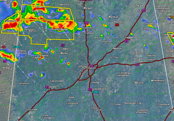
A very unstable atmosphere is in place across the state. It is allowing for very powerful storms to rapidly intensify and track south through the state. The main threat today will be damaging winds, around 60mph, but some winds could possibly be as high as 80mph. Large hail is also possible.
There is a lot of cold and dry air aloft which is conducive for hail development and we could see hail as large as ping pong balls this afternoon. Quarter size hail has been reported with the storms that moved through Winston County.
There is plenty of instability as CAPE values are over 5000 J/kg this afternoon. This will continue to allow the storms to maintain intensity as that track south through the state. Warnings should continue to be issued as the complex of storms heads south. The main line of storms will be moving into the Birmingham Metro after 3PM.
Also, a lot of lightning is occurring with these storms. Stay weather aware this afternoon!
Category: Alabama's Weather, Severe Weather
About the Author (Author Profile)
Macon, Georgia Television Chief Meteorologist, Birmingham native, and long time Contributor on AlabamaWX. Stormchaser. I did not choose Weather, it chose Me. College Football Fanatic. @Ryan_StinnetSubscribe
If you enjoyed this article, subscribe to receive more just like it.


