

Improving Weekend Weather
After a very active day of weather Friday, we are seeing better weather today as a new air mass is settling into the state. Our flow is from the east today as a wedge feature has set up over the Southeast, and that is allowing the new air mass to move in.

We are seeing mainly cloudy conditions, but we are seeing some sunshine in a few areas. Through the afternoon and evening, the sky will gradually clear. We are still seeing higher moisture levels today as well, and we can not completely rule out an isolated shower or storm, but nothing like we saw yesterday, and the vast majority of us will be staying dry. Temperatures this afternoon are in the upper 70s and 80s for most locations.
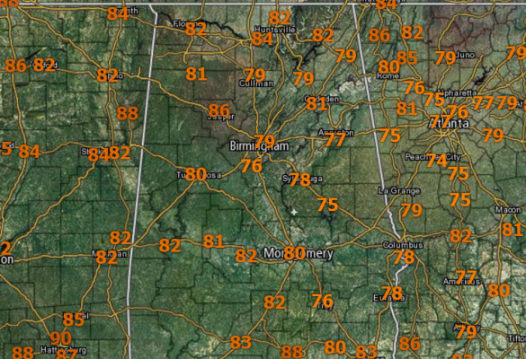
FATHER’S DAY: We start tomorrow morning off very nice with 60s for most locations. The rest of the day, expect a good-looking day of weather for all you dads out there. We are forecasting plenty of sun, highs in the upper 80s to near 90 degrees, and lower humidity levels. Any plans you have for dear old dad will have no weather issues, so enjoy.
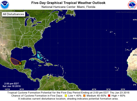
TROPICAL UPDATE: A tropical wave located near the Yucatan Peninsula is producing cloudiness and disorganized thunderstorm activity from the southern Gulf of Mexico across the Yucatan Peninsula, Belize, and the northwestern Caribbean Sea. A weak surface low pressure system could form over the southern Gulf of Mexico during the next day or so, but only gradual development is expected due to proximity to land and marginally conducive upper-level winds. This system is forecast to move west-northwestward at about 10 mph before it moves inland early next week.
Category: Alabama's Weather
About the Author (Author Profile)
Macon, Georgia Television Chief Meteorologist, Birmingham native, and long time Contributor on AlabamaWX. Stormchaser. I did not choose Weather, it chose Me. College Football Fanatic. @Ryan_StinnetSubscribe
If you enjoyed this article, subscribe to receive more just like it.


