

Slightly Drier Air for a Couple of Days
Some small early morning showers were showing up on radar in a band from Montgomery northwestward to Fayette. These were all very small and not producing much in the way of rainfall. Low clouds blanketed a good portion of Central Alabama, so it looks like most of us will wake up to some form of cloud cover. Clouds should break up by late morning with a fair amount of sunshine on this Father’s Day. The primary risk for isolated showers and thunderstorms will be across the southern third of Alabama. Dew points are down at least a few degrees and we should continue to see the dew points fall a little more, so the high of 87 will at least feel a little better with slightly drier air.
Headed to the beach? About 7 to 9 hours of sunshine is expected along the Gulf Coast from Gulf Shores to Panama City Beach through the middle part of the week. Isolated afternoon thunderstorms are possible today. Highs will be in the middle and upper 80s on the immediate coast, with lower 90s inland. With the surface high bringing onshore flow to the Gulf Coast area, the potential for rip currents is high. You can learn how to “break the grip of the rip” here. The sea water temperature at the Dauphin Island Sea Lab was 85 degrees. See the complete Gulf Coast 7 Day Planner here.
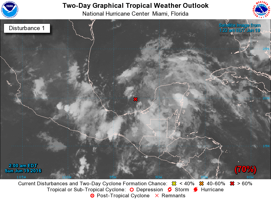
The threat for severe storms remains removed from Central Alabama with the main storm systems and the prevailing westerlies mainly along the US-Canadian border. The risk for severe storms moves from Wisconsin today to the eastern Great Lakes on Monday and then sags southward in an arc from Iowa to Virginia. The tropics are becoming a bit more active with a disturbance over the Southwest Gulf of Mexico also known as the Bay of Campeche. A Hurricane Hunter aircraft may investigate this area later today. It does not appear to be much of a threat to the US as it continues on a west-northwest course that should take it into the east coast of Mexico.
There is not a great deal to talk about in the weather pattern expected for Alabama for the next week or so. That huge ridge over the western states is forecast to nose into the Southeast US during the first part of the week ahead through about Thursday. Beginning Thursday and continuing into Friday, a strong trough pushes back against the ridge with the potential for a weak front to be dragged into the Southeast US and perhaps give us our best chance for seeing a few additional showers and thunderstorms. But the ridge pushes back by Saturday and Sunday as that front washes out and we return to those daily thunderstorms driven primarily by the heat of the day. This keeps us warm and perhaps verging on hot with highs mainly in the lower 90s or in the range from 90 to 95. Morning lows will be just about as unchanging with values in the lower 70s.
Peeking into week two, also known as voodoo country, the GFS promises another fairly strong trough to develop over the eastern third of the US from the 30th of June to the 2nd of July. And it holds that trough in place through July 4th. This pattern would keep Central Alabama out of any really high heat as we enter the first part of July.
I’ll be filling in this evening for Meaghan Thomas on ABC 3340, so you can catch the latest forecast later today at 5:30 pm and again at 10:00 pm. The next Weather Xtreme Video will be posted here by 8 am or so on Monday morning. Enjoy your day and Godspeed.
-Brian-
Category: Alabama's Weather
About the Author (Author Profile)
Brian Peters is one of the television meteorologists at ABC3340 in Birmingham and a retired NWS Warning Coordination Meteorologist. He handles the weekend Weather Xtreme Videos and forecast discussion and is the Webmaster for the popular WeatherBrains podcast.Subscribe
If you enjoyed this article, subscribe to receive more just like it.


