

Here come the 90s
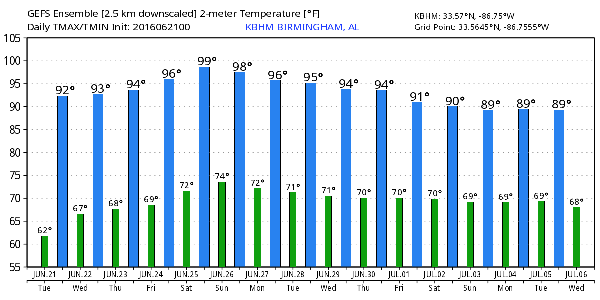
The high in Birmingham yesterday was 89 degrees, and that was probably the last time we’ll see values under 90 degrees for at least a week. There are some high cirrus clouds across Alabama this morning from convection that went on yesterday well west of us. A cold front dropping into Kentucky this morning may generate a few storms north of us, but Alabama is expected to stay dry as that huge ridge to our west expands its influence into the Southeast US. This means temperatures will go up with lower 90s for highs today. And it won’t feel quite as nice as yesterday as the dew points join the temperatures by moving upward.
Great week for beachgoers underway along the beaches of Alabama and Northwest Florida. You’ll find mostly sunny skies, only isolated afternoon and evening showers and storms, and warm temperatures typical of June this week. Highs will be near 90. Lows will be in the middle 70s. Water temperatures are climbing out of the lower 80s into the middle 80s. The detailed beach forecast can be found here.
Tropical Storm Danielle has moved into eastern Mexico and the National Hurricane Center has issued the last advisory on that storm. Elsewhere across the Tropical Atlantic things are quiet for now.
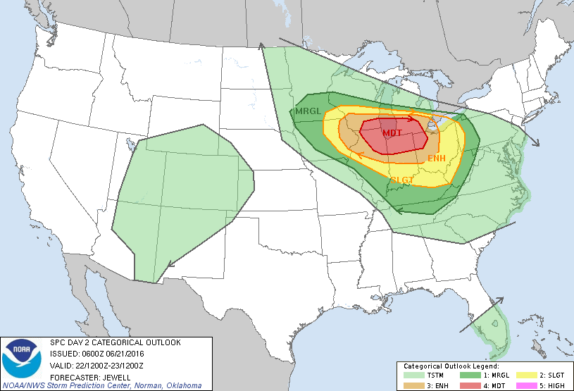
The weather system and front moving through the Great Lakes area and Mid-Atlantic States will be the focus for organized severe weather for the next three days. In fact, SPC has outlined a moderate risk for severe storms on Day 2, Wednesday, centered over Chicago. The primary threat for Day 2 will be large hail.
The upper ridge will be the primary feature in the weather pattern for the Southeast US for the next several days. The 594 height contour will cover the southern tier of the US from coast to coast Wednesday, Thursday, and Friday. A weak front will approach the Tennessee River from the north on Friday perhaps aiding in the development of afternoon showers and thunderstorms, but I’m not optimistic that many people will see rain. By Friday highs will be well into the middle 90s with some places pushing the upper 90s.
A strong upper low coming across Montana on Saturday will pump up the ridge over the eastern US even more producing what may be the hottest day we’ll see in the week ahead. Look for highs to climb into the upper 90s. A heat advisory may be required as the heat indices surge into the 105 to 108 range. Without a great deal of change, Sunday will also be hot like Saturday.
But the upper low moving across the Great Lakes on Monday and Tuesday will beat that huge ridge back to the west. That together with the front that it will drag into the Southeast US should be enough to provide us with fairly good chances for thunderstorms. Clouds and the presence of thunderstorms should also bring some relief in the heat with highs held to the lower 90s.
Did you see the Weather Xtreme Video yesterday? If you did, you may remember the impressive closed low over Arkansas around July 5th or so. Well, the GFS is sticking to its guns – sort of. The GFS still has a closed low over Arkansas on July 6th, but this one is considerably weaker than the one we saw yesterday and much more believable. Of course, we’re still talking about voodoo country.
I plan to have the next Weather Xtreme Video posted here around 7 to 7:30 tomorrow morning. Be sure to check back her for later updates on the Alabama weather scene. Have a great day and Godspeed.
-Brian-
Category: Alabama's Weather
About the Author (Author Profile)
Brian Peters is one of the television meteorologists at ABC3340 in Birmingham and a retired NWS Warning Coordination Meteorologist. He handles the weekend Weather Xtreme Videos and forecast discussion and is the Webmaster for the popular WeatherBrains podcast.Subscribe
If you enjoyed this article, subscribe to receive more just like it.


