

East and West Storms
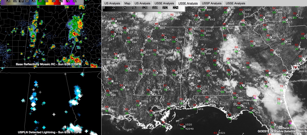
Showers and storms have developed across West Central Alabama and along the Georgia border, in the more favored areas from an instability standpoint. There are numerous from Franklin County southward through Fayette, Pickens and Western Tuscaloosa Counties on into Greene and Hale Counties. Same with the storms along the Georgia border in eastern Cleburne and Randolph Counties.
Instability is high all across the area, with CAPE values expected to be over 3,000 joules/kg. Wind shear is nearly nil, so storms won’t have much organization. But here is a significant amount of dry air in the mid levels of the atmosphere. This will give the potential for damaging downburst winds this afternoon that could lead to severe weather. Preciptable water values are not especially high, but storms could produce enough rainfall to cause flash flooding, like in Cherokee County last evening. Hail should not be a threat, with freezing levels at high altitudes, around 15,000 feet.
The storms won’t move very much for sure, with steering currents blowing at less than 10 mph from the northwest, so they will drift southeastward southeastward.. It looks like about 40-50 percent of the area could see storms this afternoon.
HEAT ADVISORY: A heat advisory is in effect for West Central Counties of the state from Marion and Winston Counties southward to Marengo and Dallas. The NWS just added Autauga, Barbour, Bullock, Chilton, Jefferson, Lowndes, Montgomery, Pike and Shelby to the advisory.
MOVING AHEAD IN TIME: The high pressure ridge will shift westward and a trough will begin to develop over the eastern United States. This will allow a cold front to approach Alabama. Showers and storms will fire on Monday afternoon ahead of the cold front and will drift southward into the Central part of the state tomorrow evening. Tuesday, the front will be drifting south, and it appears the best focus for storms will be over the Central part of the state. The front should push into South Alabama on Wednesday, giving drier conditions to the middle of the state on Wednesday and Thursday. Enough moisture should return on Friday for widely scattered afternoon and evening showers and storms to return. Then another front will approach the state from the north of Saturday, increasing chances of showers and storms again.
DANCING WITH THE STATS: Anniston’s 100 degree reading yesterday was a record for the date, breaking the old record of 98F set in 1978. The 97F at Birmingham was tied for the 8th hottest June 25th at Birmingham. Interestingly, the high on June 25, 1979 was only 69F as unseasonably cool high pressure was dominating much of the Ohio and Tennessee Valleys. It was 63F at that morning at BHM and 57F at Nashville.
Category: Alabama's Weather
About the Author (Author Profile)
Bill Murray is the President of The Weather Factory. He is the site's official weather historian and a weekend forecaster. He also anchors the site's severe weather coverage. Bill Murray is the proud holder of National Weather Association Digital Seal #0001 @wxhistorianSubscribe
If you enjoyed this article, subscribe to receive more just like it.


