

Dry Air Over North Alabama
RADAR CHECK: As expected, all of the showers and storms are over the southern half of Alabama this afternoon…
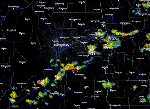
North Alabama is in very dry air; the dew point at Huntsville has dropped to 45 degrees at 3:00… the relative humidity there is only 20 percent.
Tonight will be fair and pleasant; cooler pockets will drop into the 50s tomorrow morning.
TOMORROW THROUGH SUNDAY: The stalled surface front over Central Alabama will slowly wash out, but the air will still be pretty dry, and any showers or storms during the afternoon and evening hours across the north/central counties of Alabama will be few and far between. Chance of any one spot getting wet each afternoon is only about one in five; most of the scattered storms will remain over South Alabama. The high tomorrow will be in the low 90s, followed by mid 90s Saturday and Sunday. Days will be partly to mostly sunny, and nights mostly fair.
MONDAY: A surface front will approach, and with rising moisture levels we expect scattered showers and thunderstorms to become more numerous across the state. It won’t rain all day, but a passing shower or storm is a pretty good possibility, especially during the afternoon and evening hours. Monday’s high will be close to 90 degrees.
The rest of next week should feature pretty routine July weather; hot humid days with the chance of “scattered, mostly afternoon and evening showers and thunderstorms”. See the Weather Xtreme video for maps, graphics, and more details.
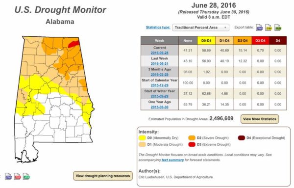
DEVELOPING DROUGHT: A decent part of Northeast Alabama is now in “severe drought” conditions…
AIR QUALITY ALERT: A code orange air quality alert has been issued for Jefferson and Shelby Counties tomorrow due to ground level ozone. Defer using gas-powered engines. Walk, bike, carpool, or use transit if possible. Link errands into one trip. Conserve energy.
TROPICS: Tropical storm formation is not expected through the holiday weekend across the Atlantic basin.
AT THE BEACH: Expect about 6 to 8 hours of sunshine each day through the Fourth of July weekend on the coast from Panama City Beach over to Gulf Shores; there will be a risk of a few scattered storms daily. Highs will be in the upper 80s on the immediate coast, with 90s inland. See a very detailed Gulf Coast forecast here.
WEATHER BRAINS: Don’t forget you can listen to our weekly 90 minute netcast anytime on the web, or on iTunes. This is the show all about weather featuring many familiar voices, including our meteorologists here at ABC 33/40.
CONNECT: You can find me on all of the major social networks…
Facebook
Twitter
Google Plus
Instagram
Look for the next Weather Xtreme video here by 7:00 a.m. tomorrow…
Category: Alabama's Weather
About the Author (Author Profile)
James Spann is one of the most recognized and trusted television meteorologists in the industry. He holds the AMS CCM designation and television seals from the AMS and NWA. He is a past winner of the Broadcast Meteorologist of the Year from both professional organizations.Subscribe
If you enjoyed this article, subscribe to receive more just like it.


