

Hot Weekend for Alabama
It’s July 4th weekend, and hot weather is what we typically expect to see, so there is no surprise that this is what you will see. A few clouds were detected in the satellite view of the Southeast, but there will be plenty of sunshine today which will see the afternoon highs climb well into the middle 90s. While the chance for a storm or two is not zero, it is very low to where most people will be dry. Don’t overdue it in the heat, and use common sense.
The pattern does not change much for Sunday though we may see a few more isolated storms, but again there should be plenty of space between them. The heat continues with highs again in the middle 90s with spots reaching into the upper 90s.
From Dauphin Island over to Panama City Beach, the holiday weekend will see 6 to 8 hours of sunshine each day with the risk of a passing shower or thunderstorm from time to time. On the immediate coast, highs will be in the upper 80s to the lower 90s, with mid 90s inland. Water temperature at Perdido Pass was 85 degrees.
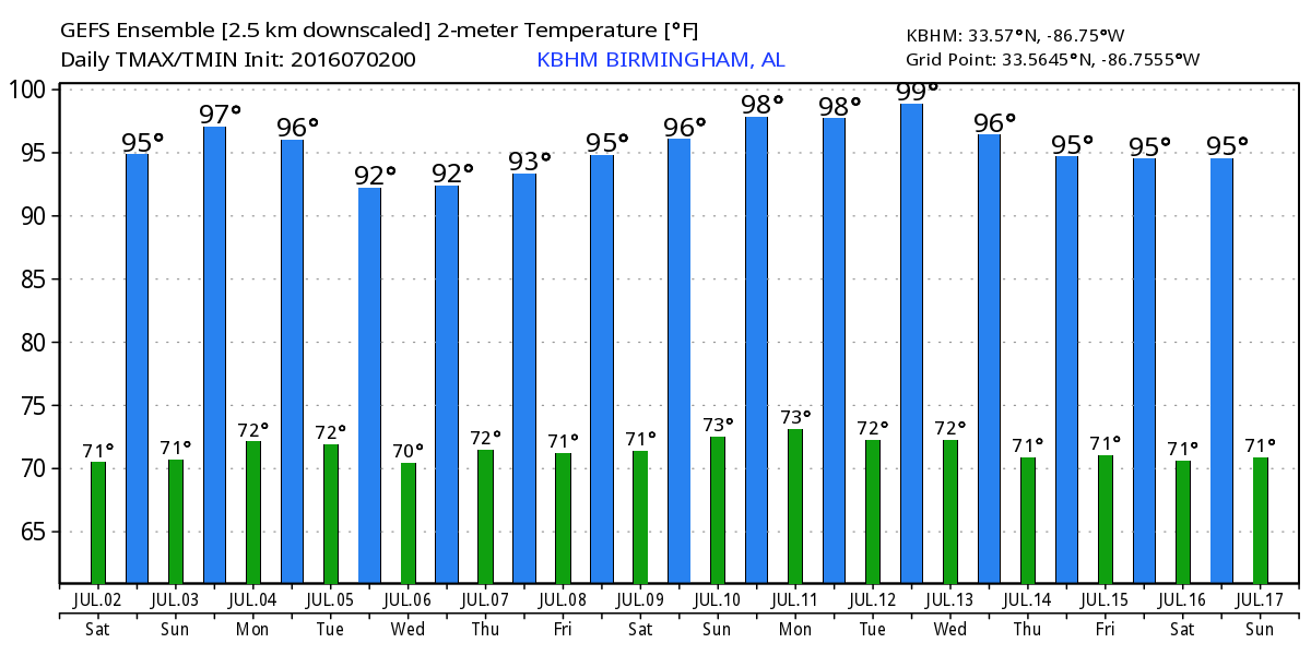
Fourth of July should be a fairly typical summer day with those diurnal storms scattered about. Moisture levels will be up a little with dew points around 70. I do expect to see a few more storms for North and Central Alabama, but there is not going to be an all day washout. Most storms will diminish with the lose of the sunshine; sunset in Birmingham is 8:01 pm. Highs will be off a few degrees thanks to the presence of more clouds.
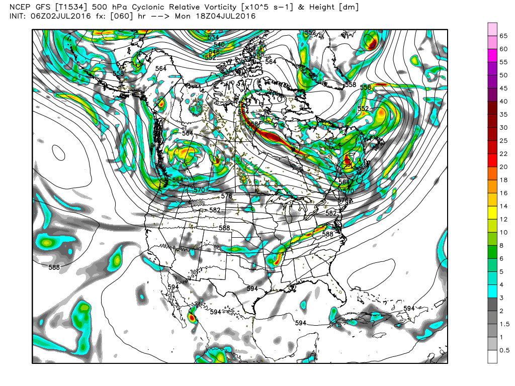
Aloft, Monday we see the approach of a weak short wave in the 500 millibar flow. This should bring our best chances to see some rain, but because the nature of the rain will be in thunderstorms, not everyone will get wet. Clouds and the presence of more storms will also help to hold the highs in the lower to middle 90s.
For the end of the week and into the weekend, there is pretty good disagreement on the part of the major models. The GFS is more aggressive with thunderstorms while the European is much less aggressive. For now, since this is five to seven days out, I’m going to stick with scattered thunderstorms with rain probabilities in the 30 to 40 percent range. I think the GFS MOS guidance numbers are too low. The MOS values are 89 to 91 for the end of the week, but I think the pattern is more likely to suggest highs in the middle 90s. Without any real change in moisture, heat indices could push toward the 105 mark, so we’ll have to be vigilant on that. Heat is a pretty big killer!
Looking into voodoo country, the GFS brings a big ridge into the eastern US around July 11th. That ridge does not last very long with a broad trough forecast for the 14th of July. The broad trough does not last long either, with a really big ridge over the eastern half of the country by the 17th of July. One think of concern on the GFS projections is that we don’t usually see this kind of variability in the summertime flow patterns, so this looks somewhat anomalous. But it is voodoo country!
I’m substituting for Meaghan Thomas on ABC 3340 News this weekend, so you can catch the latest forecast for your July 4th at 6 and 10 pm this evening. I’ll have the next Weather Xtreme Video posted here on Sunday morning by 8 or so. Enjoy the day, stay alert to the heat, and Godspeed.
-Brian-
Category: Alabama's Weather
About the Author (Author Profile)
Brian Peters is one of the television meteorologists at ABC3340 in Birmingham and a retired NWS Warning Coordination Meteorologist. He handles the weekend Weather Xtreme Videos and forecast discussion and is the Webmaster for the popular WeatherBrains podcast.Subscribe
If you enjoyed this article, subscribe to receive more just like it.


