

Severe Thunderstorm Warning for Parts of Greene and Tuscaloosa Counties
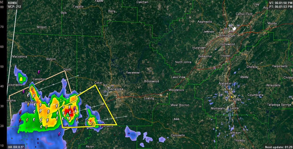
Strong thunderstorms over northeastern Greene County are moving into southwestern Tuscaloosa County at this hour. They strongest part of the storm is centered some 15 miles west southwest of the City of Tuscaloosa Moving ENE this storm will reach Tuscaloosa before 7 p.m., although rain and thunder will occur before the core arrives.
Winds could reach 60 mph and there could be one inch hail.
Lots of heavy rain and deadly lightning too.
The storm has been dumping rainfall at the rate of over an inch per hour.
THE NATIONAL WEATHER SERVICE IN BIRMINGHAM HAS ISSUED A
* SEVERE THUNDERSTORM WARNING FOR…
NORTHEASTERN GREENE COUNTY IN WEST CENTRAL ALABAMA…
SOUTHWESTERN TUSCALOOSA COUNTY IN WEST CENTRAL ALABAMA…
* UNTIL 630 PM CDT
* AT 558 PM CDT…A SEVERE THUNDERSTORM WAS LOCATED OVER MANTUA…OR
14 MILES EAST OF ALICEVILLE…MOVING NORTHEAST AT 15 MPH.
HAZARD…60 MPH WIND GUSTS AND QUARTER SIZE HAIL.
SOURCE…RADAR INDICATED.
IMPACT…HAIL DAMAGE TO VEHICLES IS EXPECTED. EXPECT WIND DAMAGE
TO ROOFS…SIDING…AND TREES.
* LOCATIONS IMPACTED INCLUDE…
MOUNDVILLE…UNION…MANTUA…JENA…ROMULUS…RALPH…SNODDY…
FOSTERS BOAT LANDING AND FOSTERS.
THIS INCLUDES INTERSTATE 20 NEAR MILE MARKER 62.
Category: Alabama's Weather, Severe Weather
About the Author (Author Profile)
Subscribe
If you enjoyed this article, subscribe to receive more just like it.


