

Weekend Stormy with Relief from Heat
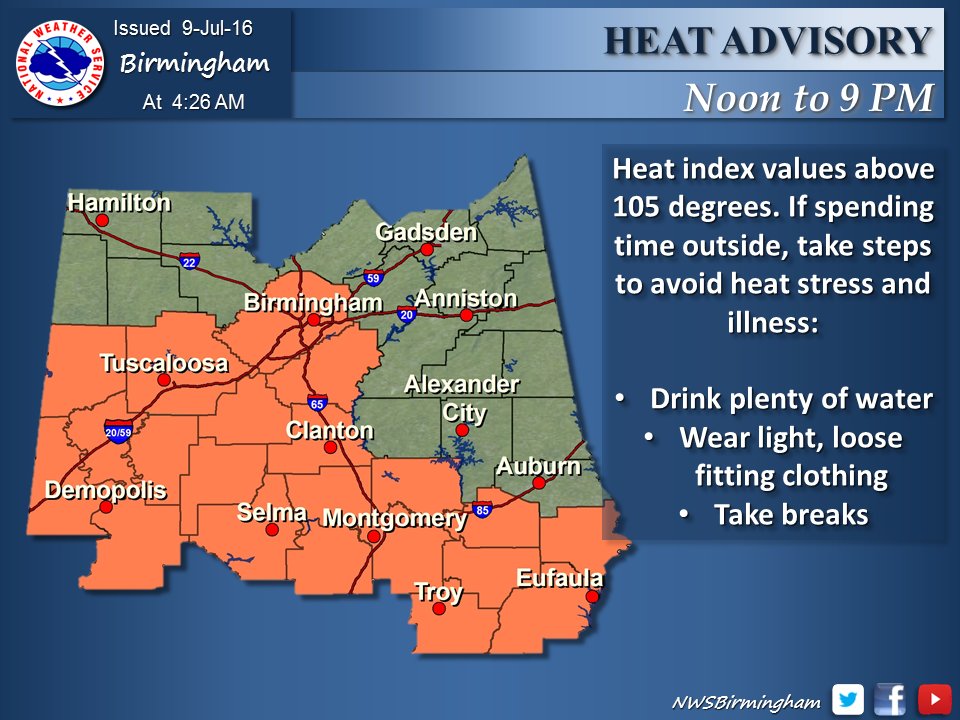
The weekend across Central Alabama is looking somewhat stormy which could bring some relief from the heat. Birmingham has seen highs of 90 degrees or higher for the last 10 days and our overnight lows have been in the upper 70s and lower 80s for the last week. For today, the NWS in Birmingham has covered much of the southern half of Central Alabama with a heat advisory as seen here.
Today will be an interesting race between the heat and the storms. Thunderstorms were occurring in parts of West Tennessee in the vicinity of Savannah and Selmer (TN) moving southeastward. So the first question of the morning is just how far those storms will be able to travel. Current motion suggests reaching Cullman in about five hours, between 11 am and noon – IF they hold together. That remains a big IF, too. Whether they do remain intact or not, these storms will leave mesoscale boundaries that will likely be the focus for additional thunderstorms to develop in the heat and humidity of the afternoon.
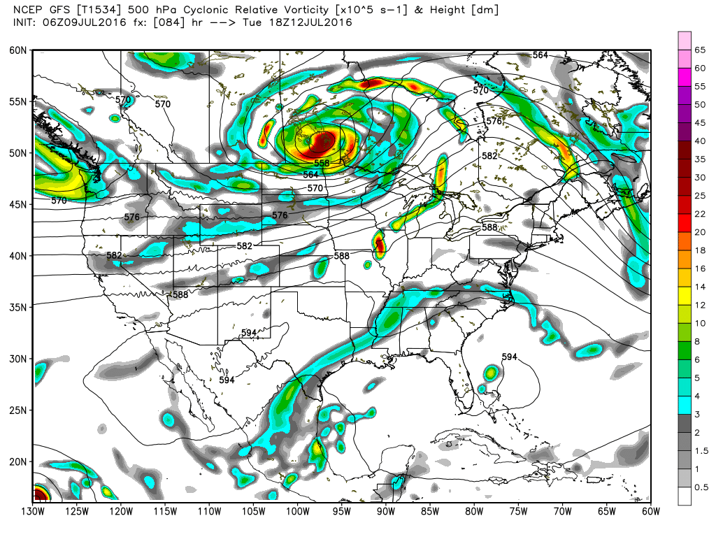
All of these storms are along and just south of a boundary stretching east to west from northern Kentucky to Southeast Nebraska which will likely slowly sag closer to Alabama without actually arriving here. Complicating the surface situation is an upper air short wave trough over eastern Oklahoma this morning that will move into the Southeast US Sunday. This feature should help to enhance our chances for thunderstorms on Sunday, so while chances for storms are good today, they should be even better on Sunday and Monday.
The tropical Atlantic remained quiet this morning, but we have Blas and Celia currently roaming the Eastern Pacific. Nepartak in the Western Pacific was a mere shadow of itself as it was going ashore in China as a dissipating tropical storm.
Back in the Southeast US, the upper air short wave that will enhance storm chances on Sunday is projected to make forecasting the weather a real challenge as we head into the early days of next week. Monday the GFS is creating a weakness in the 500 millibar flow over the Lower Mississippi River Valley. This weakness in the pressure pattern sticks around until early Wednesday when it finally edges away from Alabama over the Carolinas. This weakness in the upper level pattern should keep thunderstorm chances fairly highly through Tuesday. By Wednesday and for the latter part of the week ahead, the ridge to our west becomes a major player in our weather taking us back to heat and small, daily chances for showers and thunderstorms.
High temperature forecasts will also be a challenge. With that upper low in our vicinity, we should see additional clouds and more numerous storms, so I expect our highs to be in the range of 87 to 92 degrees. As the upper ridge increases its hold on the pattern for the latter part of the week we will see highs climb back into the lower and middle 90s.
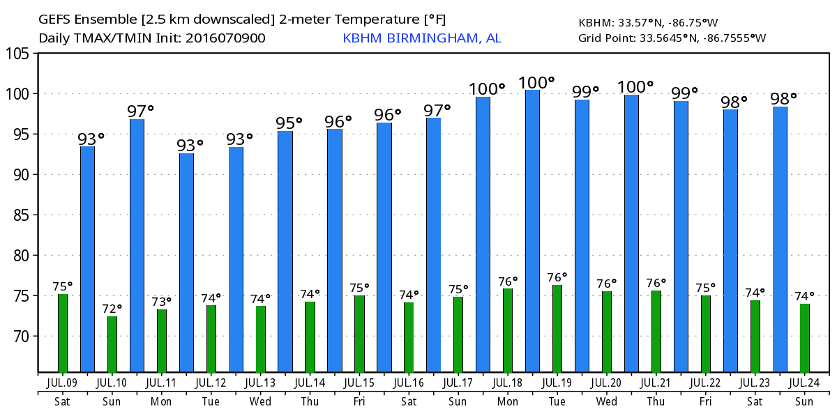
The longer range map projections by the GFS suggest a relatively hot period from the 18th of July through the 24th of July with a complete absence of any weather system to provide us with even the smallest amount of heat relief. The GFS Ensemble highs even reach 100 degrees – ouch! But you know how these voodoo country predictions can be.
I expect to have the next Weather Xtreme Video posted here first thing on Sunday morning – by 8 am or so. I hope you will enjoy your day. Please be aware of thunderstorms in your vicinity and head the threat that lightning poses – When Thunder Roars, Go Indoors! Godspeed.
-Brian-
Category: Alabama's Weather
About the Author (Author Profile)
Brian Peters is one of the television meteorologists at ABC3340 in Birmingham and a retired NWS Warning Coordination Meteorologist. He handles the weekend Weather Xtreme Videos and forecast discussion and is the Webmaster for the popular WeatherBrains podcast.Subscribe
If you enjoyed this article, subscribe to receive more just like it.


