

More Storms Today and Monday
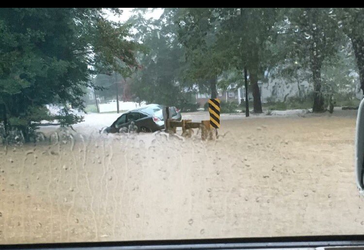
The weather is expected to remain somewhat stormy across Central Alabama again today and Monday. But as I saw yesterday, even though the storms were fairly numerous, not everyone will get rain. I saw storms come very close to my weather station in Helena, but I saw no rain of any significance – I was one of THOSE! The overall weather pattern remained somewhat unsettled and is likely to stay that way through Monday. There were more clouds present this morning leftover from all of the storms we watched on radar yesterday. The presence of clouds and storms will help to hold temperatures down with highs mainly around the 90-degree mark. At least a little relief from the heat, but no relief from the humidity. Rainfall over the next several days is expect to range from near 0 – the unlucky ones who miss out on getting a storm – to as much as an inch and a half. Rainfall could be heavy for brief periods, so it is possible to see local flash flood issues as we saw in Jasper yesterday afternoon.
Beachgoers will see scattered showers and storms for the next few days, but you will still see plenty of sun at times along the Northern Gulf Coast. Improving weather is expected toward the end of the week, as a more typical set up is expected, with six to eight hours of sunshine and those daily threats for storms. Rip currents have been in the moderate range most of the week, and that should continue the next several days. Highs on the immediate coast between 87 and 90 with mid 90s inland. The sea water temperature at Perdido Pass at Orange Beach was 83 degrees. You can find the complete Gulf Coast 7 Day Planner here.
The tropical Atlantic remained quite, but there were two storms and a disturbed area of weather in the Eastern Pacific. Blas was down to depression strength and Celia remained a tropical storm.
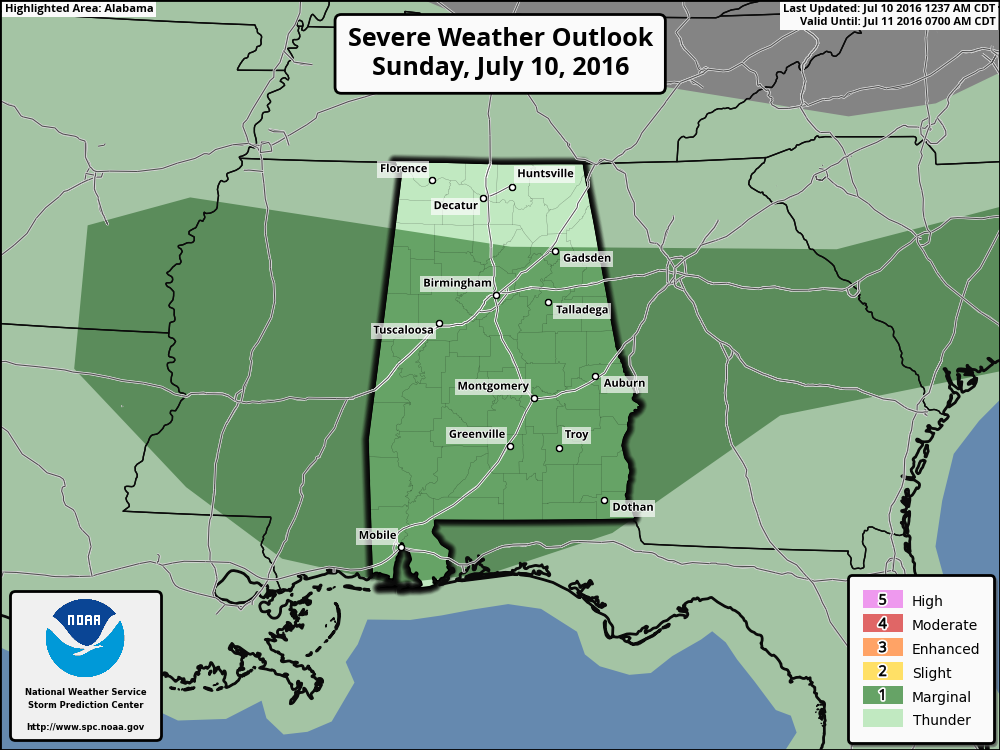
The SPC folks have outlined a marginal risk for severe storms in a wide swatch across the Southeast US including Central Alabama for today and again on Day 2. The main risk for organized severe weather is over the North Central US focused on North Dakota today and over Wisconsin and Iowa on Day 2. For Day 3, the slight risk of storms shifts into the Great Lakes area over parts of Michigan, Minnesota, and Illinois.
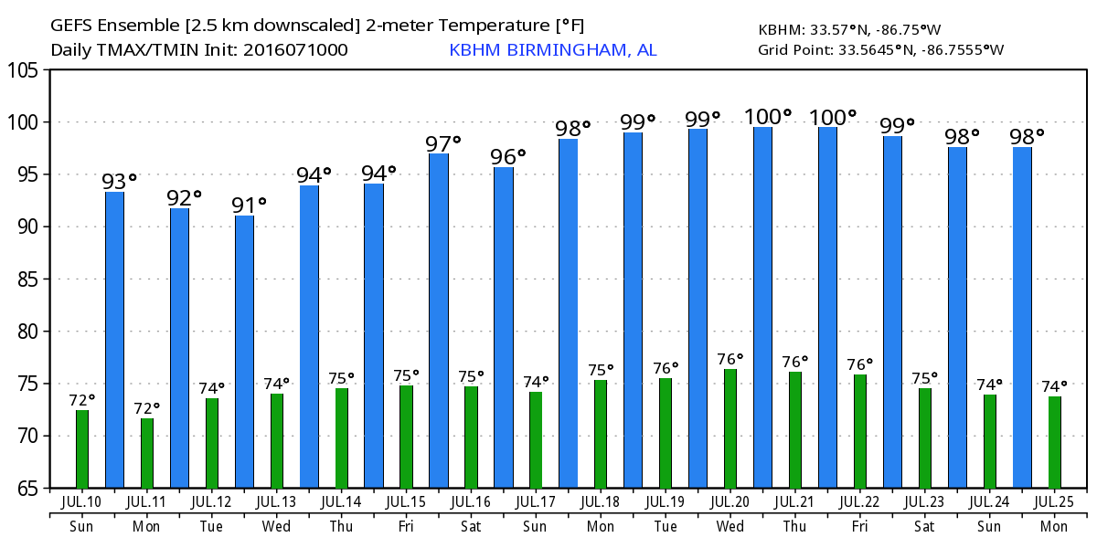
The weakness in the upper air pattern today is forecast to stick around on Monday, move east a little on Tuesday, and finally shift into the Carolinas on Wednesday. This upper weakness or area of lowered pressure will combine with daytime heating to generate storms again Monday. GFS MOS guidance numbers suggest less storms on Tuesday, but with that weakness aloft over our area, I suspect we’ll see another round of fairly numerous thunderstorms. Through Tuesday, highs are likely to remain around the 90-degree mark with the extra clouds and storms.
For the latter portion of the week ahead from Wednesday through next Sunday, the upper air pattern gradually shifts back to a ridge pattern as the upper ridge to our west strengthens and gradually pushes the traveling westerlies further north. This certainly suggests that the heat will return with the highs getting back into the middle 90s for sure and perhaps pushing into the upper 90s across southern sections of Central Alabama. With the absence of any significant feature we will see just daily chances for those isolated thunderstorms.
Looking into voodoo country, that ridge grows really strong around the 19th of July over the Central Plains. But unlike the hot pattern we saw in voodoo yesterday, the latest GFS run is developing another deep trough along the US East Coast around the 22nd. This pattern looks almost too deep/strong for this time of year. By the end of the period around the 25th, the ridge is over the West Coast with general troughiness over the eastern two-thirds of the country which would keep us out of any real extreme heat. But this is voodoo country, and there’s not a lot of skill this far out as we see in the flip from the pattern suggested yesterday.
James Spann will be back the with next edition of the Weather Xtreme Video first thing on Monday. Please remain weather aware today and do not become a statistic either with the lightning or any flash flooding that may occur. Still hoping my yard will get some rain today! Have a great day and Godspeed.
-Brian-
Category: Alabama's Weather
About the Author (Author Profile)
Brian Peters is one of the television meteorologists at ABC3340 in Birmingham and a retired NWS Warning Coordination Meteorologist. He handles the weekend Weather Xtreme Videos and forecast discussion and is the Webmaster for the popular WeatherBrains podcast.Subscribe
If you enjoyed this article, subscribe to receive more just like it.


