

Scattered Afternoon Thunderstorms
MUGGY MORNING: Temperatures are close to 70 degrees across the great state of Alabama at sunrise, and the radar is quiet. We will rise to near 90 later today with a mix of sun and clouds, and humidity levels stay high with a blanket of moist air in place.
No doubt we will have a few showers and storms around today, but as I write here often, summer convection remains a great mystery. Forecasting placement, timing, and coverage is a huge challenge, and that remains the case today. High resolution models have backed off on the coverage of afternoon storms, suggesting they will be pretty scattered in nature. However, where they form, they will be strong, and SPC has a “marginal risk” of severe storms defined for about the northern half of the state this afternoon and tonight.
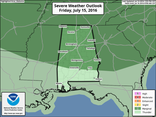
Like recent days, the main threat will come from wet microbursts (small scale areas of strong straight line winds) and small hail. All summer storms pack tremendous amounts of lightning.
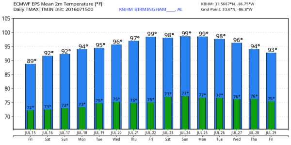
THE WEEKEND: Not much change tomorrow; the general weakness in the summer ridge persists, and we will have mixed sun and clouds with the risk of scattered, mostly afternoon and evening showers and thunderstorms. The high will be in the 89-92 degree range for most places. Then, on Sunday, storms should be fewer in number as the ridge begins to grow stronger, and temperatures rise into the mid 90s.]
NEXT WEEK: A strong upper high begins to form northwest of Alabama; we will be on the periphery of the heat wave, but still close enough for rising heat levels here. Temperatures toward the end of the week will rise into the upper 90s, and some spots could very well reach 100. As is usually the case in summer, we will have the risk of scattered storms each afternoon, but they will be pretty widely spaced thanks to warmer air aloft. See the Weather Xtreme video for maps, graphics, and more details.
TROPICS: A large amount of dry air covers the tropical Atlantic basin, and tropical storm formation is not expected anytime soon.
AT THE BEACH: Not much change; pretty standard weather for the coast from Panama City Beach over to Gulf Shores through next week. About 7 to 9 hours of sunshine daily, with a passing storm from time to time. Highs on the immediate coast 87-90, with low to mid 90s inland. See a very detailed Gulf Coast forecast here.
WEATHER BRAINS: Don’t forget you can listen to our weekly 90 minute netcast anytime on the web, or on iTunes. This is the show all about weather featuring many familiar voices, including our meteorologists here at ABC 33/40.
CONNECT: You can find me on all of the major social networks…
Facebook
Twitter
Google Plus
Instagram
I will be doing a summer program this morning at Fultondale Elementary… look for the next Weather Xtreme video here by 4:00 this afternoon. Enjoy the day!
Category: Alabama's Weather
About the Author (Author Profile)
James Spann is one of the most recognized and trusted television meteorologists in the industry. He holds the AMS CCM designation and television seals from the AMS and NWA. He is a past winner of the Broadcast Meteorologist of the Year from both professional organizations.Subscribe
If you enjoyed this article, subscribe to receive more just like it.


