

Storms Possible Again Today
*** No Weather Xtreme Video this morning due to operational weather support for the Sloss Music and Arts Festival ***
Most of Alabama is waking up to clear skies this morning, but the exception is across the northern third of the state where clouds from the convection to our west yesterday was producing mostly cloudy skies. Temperatures were in the lower 70s except for some middle 60s in the northeast portion of the state. A weak short wave at 500 millibars is likely to lead to thunderstorms becoming a bit more numerous today. The effects of the MCS (Mesoscale Convective System) on Thursday helped to stabilize our atmosphere on Friday, but I think the atmosphere has recovered enough and with the extra lift of the short wave aloft that we will see thunderstorms becoming more numerous mainly this afternoon and evening. Highs will climb into the lower 90s.
SPC has outlined a wide swath covering much of the Southeast US for today for a marginal risk of severe storms. Dry air aloft noted on the sounding at the Shelby County Airport last night will contribute to the potential for microbursts with any thunderstorms that do develop. Main threat of organized severe weather was indicated over the North Central US centered mainly on South Dakota. Day 2 and 3 severe outlooks contain the standard slight risk moving across the southern sections of the Great Lakes.
Good summer weather continues from Gulf Shores to Panama City Beach through the weekend and into most of next week. About 7 to 9 hours of sunshine each day with just an occasional passing thunderstorm. Highs 87-90 on the immediate coast with low to mid 90s inland. Sea water temperatures were mostly in the upper 80s. See a very detailed Gulf Coast forecast here.
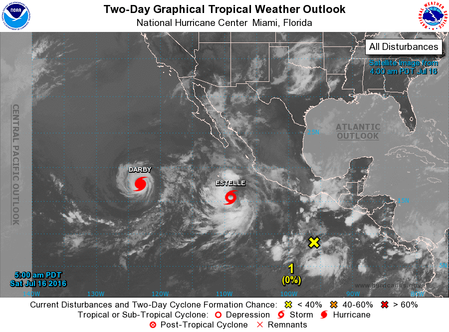
Tropical Atlantic is quiet thanks to all the dust and dry air coming across the Atlantic from the Sahara. The Eastern Pacific is not quiet with TS Estelle and Hurricane Darby. Those are followed by yet another area of disturbed weather. Both systems are well away from land and moving away from land.
The short wave at 500 millibars will move eastward tonight as the flow aloft flattens somewhat. This should bring us back to more isolated thunderstorms for Sunday, but it will remain hot. Highs Sunday in the lower 90s.
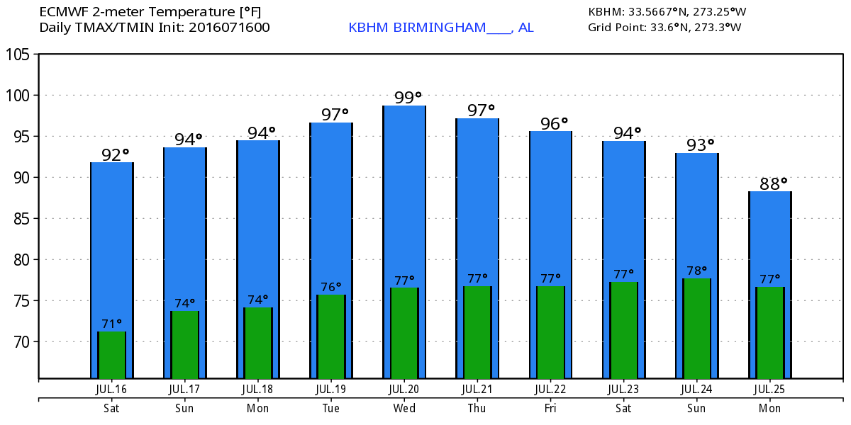
Monday and Tuesday the upper ridge to our west grows stronger and noses into the Southeast US. This should help to keep the development of thunderstorms to a minimum. But with the ridge exerting its influence our way, temperatures are likely to go up into the middle 90s with some locations pushing the upper 90s.
From Wednesday into the next weekend, the upper flow goes through another one of those cycles where a strong trough over Canada helps to push the ridge westward breaking its hold on the Southeast US. This could bring a weak front into the Southeast US around Wednesday as the upper flow becomes more of a trough over the East Coast. This pattern change should result in somewhat better chances for thunderstorms from Wednesday into next weekend, but thunderstorms will likely remain linked to the heat of the afternoon and early evening. Temperatures will be in the lower and middle 90s.
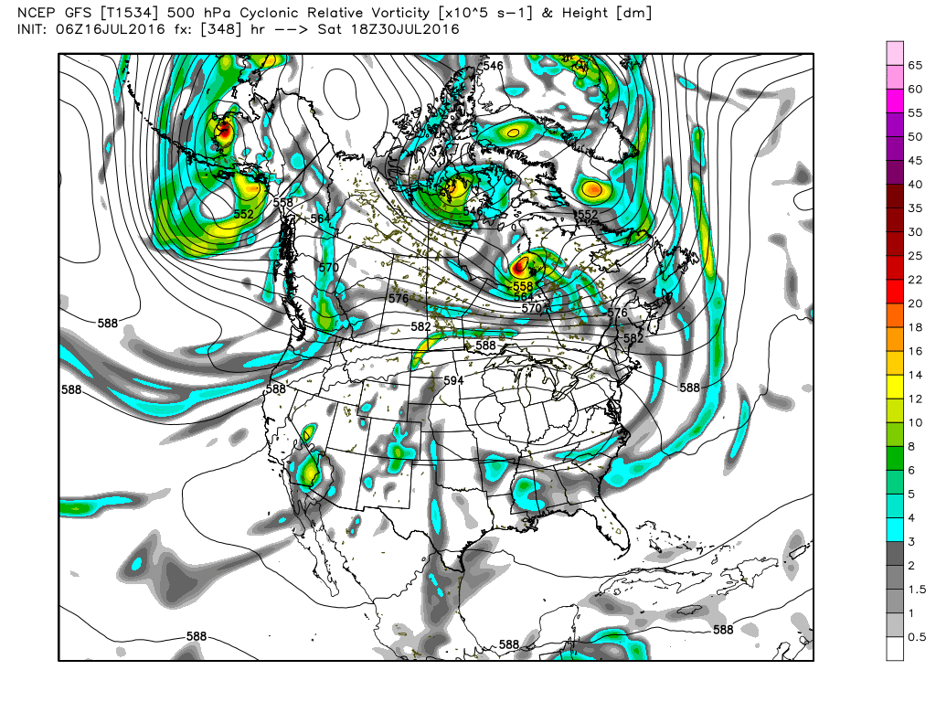
Looking into voodoo country, the GFS maintains the troughiness over the eastern US through the 28th of July. But nobody from the eastern slopes of the Rockies to the Atlantic coast will like the pattern as we end July and move into August. The GFS is bringing a huge upper ridge at 5970 meters into the Ohio River Valley. That pattern would suggest some big time heat for the eastern half of the US.
I’m sorry for the lack of a video this morning – and probably again Sunday morning – but I am working with the folks at the Sloss Music and Arts Festival to provide operational weather support to their event. I will be onsite for nearly all hours of operation beginning at 8 am. I’d say come by and say hello, but I will be working in an area not open to the public. Depending on how active the weather becomes today, I will try to post additional forecast updates during the day. And I’ll have another complete discussion tomorrow morning. Godspeed.
-Brian-
Category: Alabama's Weather
About the Author (Author Profile)
Brian Peters is one of the television meteorologists at ABC3340 in Birmingham and a retired NWS Warning Coordination Meteorologist. He handles the weekend Weather Xtreme Videos and forecast discussion and is the Webmaster for the popular WeatherBrains podcast.Subscribe
If you enjoyed this article, subscribe to receive more just like it.


