

Sizzling Summer Days
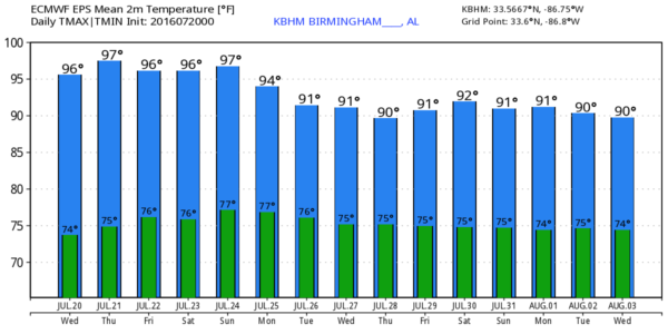
MUST BE LATE JULY IN ALABAMA: Hot summer weather will headline our forecast in coming days. The good news is that the models have backed off slightly on the expected intensity of the heat, suggesting most places will see highs in the 95-99 degree range through Friday, but there could still be a few spots reaching the 100 degree mark, especially over the northwest corner of the state, closer to the big upper high to the west.
Dew points will be up in the 70s, making the heat pretty oppressive. As I have stated here many times, you won’t see idiotic “heat tips” from me; the concern is for those that have to work outdoors during the peak of the heat and the potential for heat stroke. And, elderly people and lower income families with no air conditioning. Just watch out for those that might be at risk from the sizzling summer heat.
Days will be partly sunny, nights mostly fair, and each afternoon we will see a few random, widely scattered showers and thunderstorms. Most of them will come between 2 and 8 p.m., and the chance of any one spot getting wet will be about one in five through Friday.
THE ALABAMA WEEKEND: Heights lower a bit, and we project high mostly in the mid 90s Saturday and Sunday. Same overall idea; partly sunny days, and the risk of a few thunderstorms each afternoon in scattered spots.
NEXT WEEK: More classic summer weather. Highs will generally be in the low to mid 90s, and each day we will have the risk of “scattered, mostly afternoon and evening showers and thunderstorms”. See the Weather Xtreme video for maps, graphics, and more details.
TROPICS: Tropical storm formation is not expected anytime soon across the vast Atlantic basin.
AT THE BEACH: Great weather continues; mostly sunny days, fair nights though the weekend from Gulf Shores over to Panama City Beach. But, of course, you will probably deal with a passing storm from time to time. Highs on the immediate coast 88-91, with mid 90s inland. See a very detailed Gulf Coast forecast here.
ON THIS DATE IN 1997: Hurricane Danny has just moved into the Alabama Gulf Coast, and was only creeping along. Radar estimated an incredible 43 inches of storm total rain over the open water in Mobile Bay. Observing sites reported from 30-40 inches across the area with Dauphin Island reporting 36.71 inches.
WEATHER BRAINS: Don’t forget you can listen to our weekly 90 minute netcast anytime on the web, or on iTunes. This is the show all about weather featuring many familiar voices, including our meteorologists here at ABC 33/40. We will produce this week’s episode tonight at 8:30p CT… you can watch it live here.
CONNECT: You can find me on all of the major social networks…
Facebook
Twitter
Google Plus
Instagram
I have a weather program today at Mitchell’s Place… look for the next Weather Xtreme video here by 4:00 this afternoon… enjoy the day!
Category: Alabama's Weather
About the Author (Author Profile)
James Spann is one of the most recognized and trusted television meteorologists in the industry. He holds the AMS CCM designation and television seals from the AMS and NWA. He is a past winner of the Broadcast Meteorologist of the Year from both professional organizations.Subscribe
If you enjoyed this article, subscribe to receive more just like it.


