

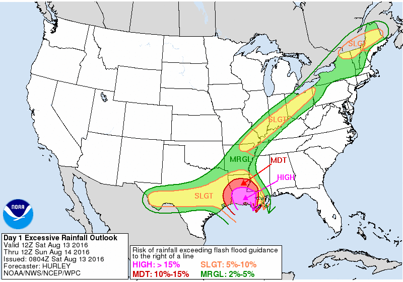
Fewer Showers for the Weekend
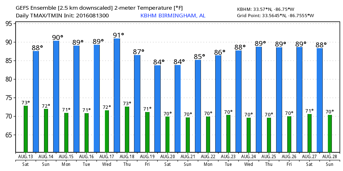
Low stratus clouds cover much of Alabama this morning, but there is one thing that is different – the radar shows very little echoes this morning, the first time in nearly a week. There is also good news for those looking for slightly drier conditions – that upper low that has been producing record rainfalls across the Lower Mississippi River Valley, especially Louisiana, has moved further from Alabama reducing its impact on us. Moisture is expected to remain the highest today across the western half of Alabama, so showers should be more numerous there and less numerous across the eastern half of the state. Clouds will again hold temperatures down with highs primary in the upper 80s, but just like yesterday, some spots will climb into the 90 to 92 range.
The weather gradually improves over the weekend with increasing amounts of sun and fewer showers and thunderstorms by Sunday. A more typical summer pattern with daily chances for showers and thunderstorms is in the forecast for the week ahead. Highs along the beach will be in the upper 80s with overnight lows in the upper 70s. Onshore flow has increased the rip current risk to high today. See a very detailed Gulf Coast forecast here.
Tropical Atlantic is quiet today and expected to remain that way for the next several days. The Eastern Pacific is fairly quiet, too, with just one area of disturbed weather to be watched.
SPC has a marginal risk for severe storms today from southern Indiana to Vermont. Day 2 identifies a marginal risk over southern New England. On Day 3, the marginal risk shifts westward to the eastern sections of the Dakotas and Southwest Minnesota.
Last week, the GFS did a pretty good job of identifying this was upper low that has produced the record rainfalls over the Lower Mississippi River Valley. That low will continue to be the focus for additional high rainfall amounts as it slowly weakens through the beginning of the week. Central Alabama will see a slight reduction in the overall moisture content in our atmosphere, so showers and thunderstorms will be less numerous Sunday and into Monday. Temperatures will creep up again with highs in the lower 90s Sunday and Monday.
Tuesday, Wednesday, and Thursday we’ll see a trough move across the Great Lakes region which will help to drag a cold front into the Ohio and Tennessee River valleys. It does not appear likely that the front will actually pass through the Southeast US. Instead, it is likely to hangup to our north over Tennessee. But with the front in close proximity, we should see the chances for showers and thunderstorms edge upward somewhat. They will still be driven primarily by the heat of the afternoon. High temperatures will be bouncing around the 90-degree mark while lows will stay in the lower half of the 70s.
By Friday and into the weekend, the upper air pattern shows more ridging as the frontal boundary washes out. This returns us to scattered afternoon showers and storms with highs in the 88 to 92 range.
The long term look is promising with a fairly strong trough coming across the Mississippi River around the 22nd of August. This could bring a pretty good chance for that first front and a hint at Fall. That one is followed by another one around the 25th of August. And we end the long range period with a nice trough along the East Coast with a ridge along the eastern slopes of the Rockies. With this pattern, we should stay out of any extreme heat.
I expect to have the next Weather Xtreme Video posted here by 7 am or so on Sunday. I hope that you have a great day. Godspeed.
-Brian-
Category: Alabama's Weather
About the Author (Author Profile)
Brian Peters is one of the television meteorologists at ABC3340 in Birmingham and a retired NWS Warning Coordination Meteorologist. He handles the weekend Weather Xtreme Videos and forecast discussion and is the Webmaster for the popular WeatherBrains podcast.Subscribe
If you enjoyed this article, subscribe to receive more just like it.


