

Routine Summer Weather For Now
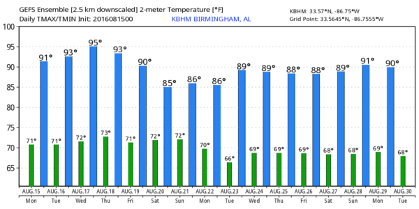
HOTTER AFTERNOONS: Birmingham went six consecutive days with a high under 90 degrees last week (Monday August 8 through Saturday August 13)… that was mostly due to increased cloud cover from the upper low that brought the historic flooding to Louisiana. That feature is now over Texas and Oklahoma, and the upper ridge has returned. This means some fairly typical August weather for the state through Wednesday; partly sunny, hot, humid days with “scattered, mostly afternoon and evening showers and thunderstorms”. Highs in the low 90s, and the chance of any one spot getting wet each day about one in four. Most of the scattered storms will happen between 2 and 9 p.m.
THURSDAY/FRIDAY: The upper ridge begins to weaken again, and we expect a slow uptick in the number of scattered showers and storms with a mix of sun and clouds both days. Highs drop into the 87-90 degree range for most communities.
THE ALABAMA WEEKEND: With a weaker ridge, and a surface front slowly approaching from the north, looks like we will have scattered to numerous showers and storms Saturday and Sunday with highs back in the mid to upper 80s. Understand it won’t rain all weekend, but a passing shower or storm is a pretty good possibility from time to time.
NEXT WEEK: The GFS actually tries to bring a surface front all the way down to U.S. 80 by Monday, and it by chance that is correct, the humidity would be a bit lower over North Alabama early next week with cooler nights, but I will believe it when I see it. Fronts rarely push that far south in August. The good news is that we see no excessively hot weather (upper 90s or triple digits) around here for the rest of the month. See the Weather Xtreme video for maps, graphics, and more details.
AT THE BEACH: Pretty good weather on the coast this week from Gulf Shores over to Panama City Beach. About 7 to 9 hours of sunshine daily with only widely scattered showers and storms; highs 87-90 on the immediate coast, with low 90s inland. The sea water temperature this morning at the Dauphin Island Sea Lab is 82 degrees. See a very detailed Gulf Coast forecast here.
TROPICS: A tropical wave has emerged off the coast of Africa; some chance of slow development in coming days, but it will be fighting dry air, and if it survives more than likely it will not impact the U.S.
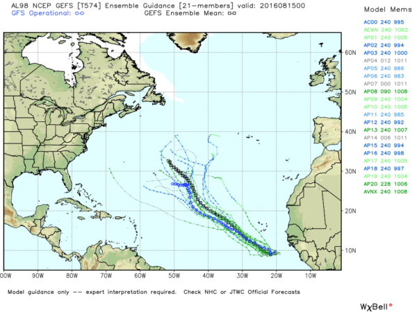
The rest of the Atlantic basin is quiet.
WEATHER BRAINS: Don’t forget you can listen to our weekly 90 minute netcast anytime on the web, or on iTunes. This is the show all about weather featuring many familiar voices, including our meteorologists here at ABC 33/40. We will produce this week’s show tonight at 8:30 CT… you can watch it live here.
CONNECT: You can find me on all of the major social networks…
Facebook
Twitter
Google Plus
Instagram
Look for the next Weather Xtreme video here by 4:00 this afternoon… enjoy the day!
Category: Alabama's Weather
About the Author (Author Profile)
James Spann is one of the most recognized and trusted television meteorologists in the industry. He holds the AMS CCM designation and television seals from the AMS and NWA. He is a past winner of the Broadcast Meteorologist of the Year from both professional organizations.Subscribe
If you enjoyed this article, subscribe to receive more just like it.


