

Hit and Miss Afternoon Showers
RADAR CHECK: Pretty much a classic dog day afternoon across Alabama, except temperatures are a bit below average with many places in the upper 80s. On radar, we have a random pattern of widely scattered showers and thunderstorms… moving north.
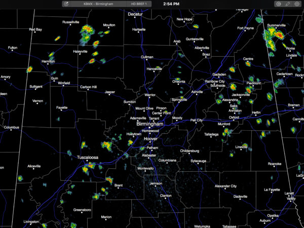
Showers and storms will fade away after the sun sets.
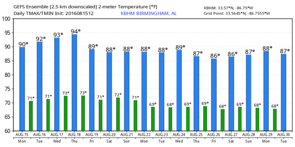
The weather won’t change much tomorrow… partly sunny with a few afternoon and evening showers and storms in random, scattered places. The high will be in the low 90s for most.
WEDNESDAY THROUGH FRIDAY: The upper ridge weakens a bit, and with slightly colder air aloft we expect scattered showers and storms to become a little more numerous on these three days. Otherwise, expect a mix of sun and clouds with highs near, or just under 90 degrees.
THE ALABAMA WEEKEND: Not much change. The sun will be out at times Saturday and Sunday, but with a moist, unstable airmass in place, and a surface front to the north, we expect scattered to numerous showers and storms both days, especially during the afternoon and evening hours. Afternoon highs will range from 87 to 90 degrees for most places, which is below average for mid-August in Alabama.
NEXT WEEK: The surface front to the north will probably hang up around the Tennessee state line; low confidence any drier air will work in here. So, no major changes for at least the first half of the week with mixed sun and clouds and the risk of scattered showers and thunderstorms. Long range guidance hints that highs could very well be mostly in the upper 80s next week.
AT THE BEACH: About 7 to 9 hours of sunshine each day through the weekend on the Gulf Coast from Panama City Beach westward to Gulf Shores, with a few widely scattered showers and storms around. Highs in the upper 80s on the immediate coast, with low 90s inland. See a very detailed Gulf Coast forecast here.
TROPICS: A tropical wave in the far eastern Atlantic has come chance for slow development through mid-week, but in the long term it will be gaining latitude and fighting dry air; looks like no risk to the U.S. or any land mass. The rest of the Atlantic basin is quiet.
WEATHER BRAINS: Don’t forget you can listen to our weekly 90 minute netcast anytime on the web, or on iTunes. This is the show all about weather featuring many familiar voices, including our meteorologists here at ABC 33/40. We will produce this week’s show tonight at 8:30 CT… you can watch it live here.
CONNECT: You can find me on all of the major social networks…
Facebook
Twitter
Google Plus
Instagram
Look for the next Weather Xtreme video here by 7:00 a.m. tomorrow…
Category: Alabama's Weather
About the Author (Author Profile)
James Spann is one of the most recognized and trusted television meteorologists in the industry. He holds the AMS CCM designation and television seals from the AMS and NWA. He is a past winner of the Broadcast Meteorologist of the Year from both professional organizations.Subscribe
If you enjoyed this article, subscribe to receive more just like it.


