

Unsettled Summer Weather Through The Weekend
RADAR CHECK: As expected, showers and storms have become more numerous across the great state of Alabama this afternoon. Some spots are getting very heavy amounts of rain and very frequent lightning as they move east/northeast…
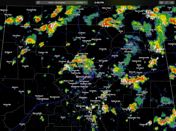
We will maintain the chance of showers and storms tonight as the upper ridge continues to weaken across the Deep South, but the trend will be for fewer showers after 9 p.m.
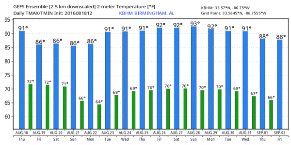
TOMORROW AND THE WEEKEND: Not much change; a rather unsettled period of weather is likely with moist, unstable air in place and the lack of a strong upper ridge. The sky will be cloudy at times each day, and we expect scattered to numerous showers and thunderstorms daily. They will be move active during the afternoon and evening hours, but we can’t rule out some late night or morning showers as well. Highs will be generally in the mid to upper 80s, and sunshine will be in limited supply.
Rain distribution will be uneven, but average rain amounts of 1-2 inches are likely by Sunday. No organized severe weather is expected, but understand any summer storm in Alabama can produce a wet microburst (a local area of damaging straight line winds), and most of them bring a tremendous amount of lightning.
NEXT WEEK: Models continue to show a nice surge of drier, continental air dropping into Alabama Monday. We will maintain a shower-free forecast Monday through Thursday of next week, which is pretty rare for August in Alabama. Humidity levels will be lower, nights a little cooler. In fact, many of the normally cooler spots have a good chance of reaching the upper 50s early Tuesday morning for a nice touch of fall. A few showers could return late in the week; see the Weather Xtreme video for maps, graphics, and more details.
AT THE BEACH: About 7 to 9 hours of sunshine daily on the coast from Panama City Beach over to Gulf Shores through the weekend, with the risk of scattered showers and thunderstorms. Highs on the immediate coast will be in the 87-90 degree range, with low 90s inland. See a very detailed Gulf Coast forecast here.
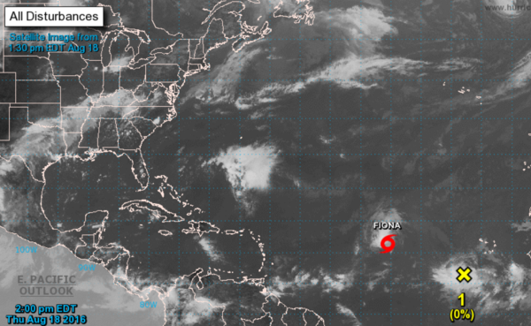
TROPICS: Tropical Storm Fiona will be gaining latitude across the open Atlantic in coming days, and is expected to stay below hurricane strength. Odds remain high this won’t impact any land mass.
Another tropical wave east of Fiona has potential to become a tropical depression or storm in a few days; it will be at a lower latitude, and will get the name “Gaston”. Something to watch in coming days…
WEATHER BRAINS: Don’t forget you can listen to our weekly 90 minute netcast anytime on the web, or on iTunes. This is the show all about weather featuring many familiar voices, including our meteorologists here at ABC 33/40.
CONNECT: You can find me on all of the major social networks…
Facebook
Twitter
Google Plus
Instagram
I had a great time today visiting with the students at West Jasper Elementary School… be looking for them on the Pepsi KIDCAM today at 5:00 on ABC 33/40 News! The next Weather Xtreme video will be posted here by 7:00 a.m. tomorrow…
Category: Alabama's Weather
About the Author (Author Profile)
James Spann is one of the most recognized and trusted television meteorologists in the industry. He holds the AMS CCM designation and television seals from the AMS and NWA. He is a past winner of the Broadcast Meteorologist of the Year from both professional organizations.Subscribe
If you enjoyed this article, subscribe to receive more just like it.


