

Midday Nowcast: Scattered to Numerous Showers Expected Through Sunday
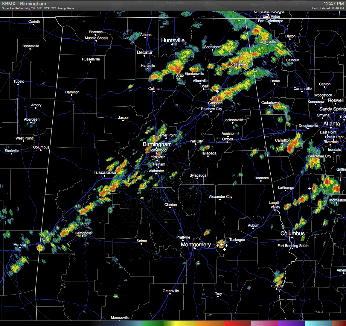
RADAR CHECK: At this hour, a broken line of showers and thunderstorms are lined up from the northeast to the southwest across Central Alabama along the I-59 and I-20 corridor. These are all slowly moving to the east. There is more shower activity in the northern part of the state.
TEMPERATURES AT THIS HOUR: With the cloud cover and the rainfall over the northern half of the area, temperatures are being held back. Temperatures are warmer where more sunshine is making it to the surface. Here is a list of temperature observations from across the area at 12:30 PM:
Birmingham 81
Tuscaloosa 81
Gadsden 86
Anniston 88
Cullman 82
Jasper 86
Alexander City 90
Selma 88
Montgomery 89
CODE GREEN AIR QUALITY: The Air Quality Index for the Birmingham Metropolitan Area is in the “Code Green” for ozone and particulate matter 2.5. No actions needed.
TODAY’S CLIMATOLOGY FOR BIRMINGHAM: The normal high for August 19th is 91, while the normal low is 69. The record high for today was set back in 1999 at 103. The record low was set back in 1992 at 62.
REMAINDER OF TODAY: Looking at the latest data, for the rest of the afternoon, most of the scattered shower and thunderstorm activity will probably be along and north of the I-20 corridor. Later this afternoon and evening, more showers and storms will form and move into the southwestern portions of Central Alabama from Mississippi, and may last into the early morning hours of Saturday as they slowly progress eastward into the south-central parts of the area. Otherwise, a mix of sun and clouds can be expected, and afternoon highs will be in the upper 80s to just over 90 degrees.
HIGH SCHOOL FOOTBALL TONIGHT: Unfortunately, summer storms tend to be very random and scattered, and there is no skill in knowing exactly when and where they will pop up in advance. The chance of any one high school stadium seeing rain tonight at kickoff time is about one in three, and in some cases lightning will be an issue. Temperatures will be generally in the low 80s at kickoff, dropping into the 70s during the second half of the games with very high humidity levels.
THE WEEKEND WEATHER: Much of the same story for Central Alabama on Saturday, as a blanket of moist and unstable air continues to cover the state. Occasional clouds with scattered to numerous showers and thunderstorms, being most active during the afternoon and evening hours. Highs will be in the upper 80s to near 90 degrees. On Sunday, a surface front will approach North Alabama and may bring some drier air to the extreme northern counties. Otherwise, the same story for the rest of Central Alabama. Scattered to numerous showers and storms, with highs in the 85-90 degree range.
HEADED TO THE BEACH: About 7 to 9 hours of sunshine over the weekend with a few scattered showers and storms from Gulf Shores to Panama City Beach; pretty much the same type weather on through much of next week. Highs on the immediate coast will stay in the 87-90 degree range, with low 90s inland. Sea water temperatures are mostly in the mid to upper 80s. See a very detailed Gulf Coast forecast here.
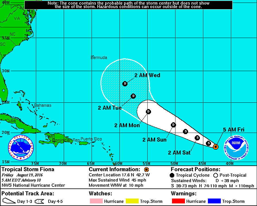
THE TROPICS: Tropical Storm Fiona is in the open Atlantic and will gain latitude in coming days, and is expected to weaken to a tropical depression over the weekend due to dry air in the surrounding environment. Fiona will likely recurve and will not be a threat to land. Another tropical wave has developed to the east of Fiona has a chance of developing in coming days, and is expected to become Tropical Storm Gaston. It will take a more southerly track, and should be approaching the Leeward Islands in about 4-5 days. Global models, however, turn this northward before reaching the Caribbean, and for now it doesn’t look like a threat for the Gulf of Mexico. Remains to be seen if this will recurve over the open Atlantic (which the ECMWF suggests) or not.
ON THIS DAY IN 1987: Thunderstorms moving out of southeastern Nebraska spread severe weather into eastern Kansas and western Missouri during the day. Thunderstorms in Nebraska produced hail three inches in diameter at Albion, and high winds which downed a large tent at Waterloo injuring a dozen persons. Thunderstorms in Kansas produced baseball size hail northwest of Topeka, and wind gusts to 80 mph at Fulton. Ten persons were injured in a thunderstorm at Princeton KS, and damage to crops in southern Franklin County KS was estimated at 3.5 million dollars.
THE BLOG IS ON TWITTER: Be sure to follow the Alabama Wx Weather Blog on Twitter. Just click here to start following our feed.
WEATHERBRAINS: This week, we previewed the upcoming National Weather Association Annual Meeting with the President, Executive Director, Social Media Chair and Program Chair. This is the show all about weather featuring many familiar voices, including our meteorologists at ABC 33/40. You can listen anytime on the web, or on iTunes. You can find it here.
ADVERTISE WITH US: Deliver your message to a highly engaged audience by advertising on the AlabamaWX.com website. The site enjoyed 10.2 MILLION pageviews in the past 12 months. Don’t miss out! We can customize a creative, flexible and affordable package that will suit your organization’s needs. Contact Bill Murray at (205) 687-0782.
Category: Alabama's Weather
About the Author (Author Profile)
Scott Martin is an operational meteorologist, professional graphic artist, musician, husband, and father. Not only is Scott a member of the National Weather Association, but he is also the Central Alabama Chapter of the NWA president. Scott is also the co-founder of Racecast Weather, which provides forecasts for many racing series across the USA. He also supplies forecasts for the BassMaster Elite Series events including the BassMaster Classic.Subscribe
If you enjoyed this article, subscribe to receive more just like it.


